Cecil_Plains,_Queensland
Cecil Plains, Queensland
Town in Queensland, Australia
Cecil Plains is a rural town and locality in the Toowoomba Region, Queensland, Australia.[2][3] In the 2016 census, the locality of Cecil Plains had a population of 429 people.[1]
Download coordinates as:
| Cecil Plains Queensland | |||||||||||||||
|---|---|---|---|---|---|---|---|---|---|---|---|---|---|---|---|
St. Margaret's Anglican Church, 1975 | |||||||||||||||
| Coordinates | 27.5316°S 151.1930°E / -27.5316; 151.1930 (Cecil Plains (town centre)) | ||||||||||||||
| Population | 429 (2016 census)[1] | ||||||||||||||
| • Density | 1.1844/km2 (3.068/sq mi) | ||||||||||||||
| Postcode(s) | 4407 | ||||||||||||||
| Area | 362.2 km2 (139.8 sq mi) | ||||||||||||||
| Time zone | AEST (UTC+10:00) | ||||||||||||||
| Location | |||||||||||||||
| LGA(s) | Toowoomba Region | ||||||||||||||
| State electorate(s) | |||||||||||||||
| Federal division(s) | Maranoa | ||||||||||||||
| |||||||||||||||
Cecil Plains is in the Darling Downs, 217 kilometres (135 mi) west of the state capital, Brisbane. The fertile black soil around Cecil Plains is ideal for cotton production and the town is now the home of one of the largest cotton gins in the southern hemisphere.[4]
The Pampas-Horrane Road (State Route 82) enters the locality from the south and then turns west on Toowoomba–Cecil Plains Road. In the town State Route 82 turns north on Dalby–Cecil Plains Road. Millmerran-Cecil Plains Road and Cecil Plains-Moonie Road both enter from the west.[5]
European settlement in the area began in 1842, when Henry Stuart Russell claimed land around the Condamine River to establish Cecil Plains station. The site of the station homestead was to become the site of the town. Ludwig Leichhardt used the homestead as a base for two expeditions into the surrounding region in 1844 and 1847. The station originally grazed cattle but later moved to wool production.[4]
The town takes its name from the pastoral station, which in turn was named after Russell's mother Cecil Charlotte Russell, née Pemberton.[2]
In 1877, 8,300 acres (3,400 ha) of land was resumed from the Cecil Plains pastoral run to establish smaller farms. The land was offered for selection on 24 April 1877.[6]
Cecil Plains Provisional School opened on 17 January 1898. It closed briefly in 1910 and 1912 and then again from 10 October 1917 to 17 June 1919. It became Cecil Plains State School on 1 February 1922. In 1964, a secondary department was added. In 1975, a pre-school centre was added.[7][8]
In 1916, Cecil Plains station was acquired by the Queensland government and subdivided for closer settlement, with some parcels reserved for soldier settlers. The new settlers produced mainly wheat and dairy. [4]
The Cecil Plains railway arrived in 1919 with the town being served by the Cecil Plains railway station (27.5336°S 151.1900°E / -27.5336; 151.1900 (Cecil Plains railway station)).[9][10]
The post office in 1921 (a receiving office had been open from 1890).[11]
Haslemere State School opened in July 1925. It closed on 28 July 1961.[7] The school was located at 2811 Pampas Horrane Road (27.59145°S 151.24157°E / -27.59145; 151.24157 (Haslemere State School (former))).[12][13]
In November 1925, the Anglican Diocese of Brisbane provided a loan of £250 to establish a church in Cecil Plains.[14] St Margaret's Anglican Church was dedicated on Sunday 2 January 1927 by Archdeacon Glover. The architect was Mr Marks of Toowoomba and the timber church was built by J. Johnson of Dalby.[15][16][17]
On Sunday 21 December 1930, Bishop James Byrne officially opened and blessed Our Lady of Lourdes Catholic Church.[18][19]
A police station opened in 1934.[4]
The local pub is called the Victory Hotel, as a result of a successful vote in 1938 (on the third attempt) to establish a drinking establishment in the town.[4]
Cecil Plains Presbyterian Church was officially opened in 1938. It was at 51 Geraghty Street and has now been converted into a house.[20][21]
Cecil Plains Airfield (also known as Tipton Airfield) was established in early 1942 during World War II, when a Japanese invasion of Australia was feared.[22] Although built for use by US Air Force bombers, it was never used by the US Air Force. From 19 December 1944 until late April 1945, the RAAF's 12 Squadron was based there flying Vultee Vengeances and B-24 Liberators. The RAAF's 102 Squadron operated from the airfield from May 1945, relocating to RAAF Base Amberley by the end of 1945.[23] The airfield had two cross runways and was off Cook Road (27.4627°S 151.2094°E / -27.4627; 151.2094 (Cecil Plains Airfield (World War II))); the runways and taxiways are still visible in the aerial imagery.[24]
From the 1960s, cotton became the main crop grown in the area.[4]
In the 2011 census, the locality of Cecil Plains had a population of 678 people.[25]
In the 2016 census, the locality of Cecil Plains had a population of 429 people.[1]
Cecil Plains is host to a number of recreational facilities, including the Cecil Plains Golf Club and Apex Park at the Cecil Plains Weir.
The Cecil Plains Library is operated by the Toowoomba Regional Council and opened in 1987.[26] The library is located on Taylor Street and is open three days a week.[27] Public accessible wifi is provided.[26] Current services and collections can be found at the Toowoomba Regional Council Library Service website.[28]
St Margaret's Anglican Church holds fortnightly Sunday services; it is part of the parish of St John's of Dalby.[29] The church is on Watson Street on the south side of the railway station, set among trees (27.5344°S 151.1922°E / -27.5344; 151.1922 (St Margaret's Anglican Church)).[30]
Our Lady of Lourdes Catholic Church is at 21-23 Geraghty Street (27.5314°S 151.1958°E / -27.5314; 151.1958 (Our Lady of Lourdes Catholic Church)). It is part of the Millmerran Parish. It holds monthly services.[31]
Cecil Plains State School is a government primary and secondary (Prep-9) school for boys and girls at Taylor Street (27.5323°S 151.1928°E / -27.5323; 151.1928 (Cecil Plains State School)).[32][33] In 2017, the school had an enrolment of 57 students with 13 teachers (9 full-time equivalent) and 11 non-teaching staff (7 full-time equivalent).[34] In 2018, the school had an enrolment of 65 students with 13 teachers (10 full-time equivalent) and 14 non-teaching staff (7 full-time equivalent).[35]
The nearest government secondary school offering education to Year 12 is Dalby State High School in Dalby to the north.[13]
- Australian Bureau of Statistics (27 June 2017). "Cecil Plains (SSC)". 2016 Census QuickStats. Retrieved 20 October 2018.

- "Cecil Plains – town in Toowoomba Region (entry 6703)". Queensland Place Names. Queensland Government. Retrieved 7 March 2022.
- "Cecil Plains – locality in Toowoomba Region (entry 49368)". Queensland Place Names. Queensland Government. Retrieved 7 March 2022.
- "Cecil Plains". Travel. Sydney Morning Herald. 8 February 2004. Archived from the original on 9 August 2014. Retrieved 8 June 2007.
- Cecil Plains, Queensland (Map). OpenStreetMap. Archived from the original on 15 July 2022. Retrieved 18 January 2022.
- "Proclamations under the New Land Acts". The Brisbane Courier. Queensland, Australia. 2 March 1877. p. 3. Archived from the original on 27 August 2020. Retrieved 19 February 2020 – via Trove.
- Queensland Family History Society (2010), Queensland schools past and present (Version 1.01 ed.), Queensland Family History Society, ISBN 978-1-921171-26-0
- "Our school". Cecil Plains State School. 6 February 2020. Archived from the original on 1 March 2022. Retrieved 15 July 2022.
- Tulk, Darren (August 2008). "The Oakey Region". Australian Railway History: 251–264.
- "Cecil Plains – railway station in the Toowoomba Region (entry 6706)". Queensland Place Names. Queensland Government. Retrieved 15 June 2020.
- Premier Postal History. "Post Office List". Premier Postal Auctions. Archived from the original on 15 May 2014. Retrieved 10 May 2014.
- "Parish of Cecil Plains Sheet 1 County of Aubigny" (Map). Queensland Government. 1932. Archived from the original on 25 January 2021. Retrieved 25 January 2021.
- "Queensland Globe". State of Queensland. Retrieved 25 January 2021.
- "THE CHURCHES". Daily Standard. No. 4009. Queensland, Australia. 14 November 1925. p. 2. Archived from the original on 25 January 2021. Retrieved 1 July 2020 – via National Library of Australia.
- "CHURCH DEDICATION". The Dalby Herald. Queensland, Australia. 4 January 1927. p. 3. Archived from the original on 25 January 2021. Retrieved 1 July 2020 – via National Library of Australia.
- "St Margaret's Anglican Church". Churches Australia. Archived from the original on 1 July 2020. Retrieved 15 July 2022.
- Blake, Thom. "St Margaret's Anglican Church". Queensland religious places database. Archived from the original on 16 July 2022. Retrieved 15 July 2022.
- "Our Lady of Lourdes Catholic Church". Churches Australia. Archived from the original on 16 July 2022. Retrieved 16 July 2022.
- Blake, Thom. "Our Lady of Lourdes Catholic Church". Queensland religious places database. Archived from the original on 16 July 2022. Retrieved 16 July 2022.
- Blake, Thom. "Cecil Plains Presbyterian Church". Queensland religious places database. Archived from the original on 16 July 2022. Retrieved 15 July 2022.
- "Cecil Plains Presbyterian Church - Former". Churches Australia. Archived from the original on 16 July 2022. Retrieved 15 July 2022.
- "Cecil Plains Airfield". Queensland WWII Historic Places. Queensland Government. 30 June 2014. Archived from the original on 13 March 2022. Retrieved 15 July 2022.
- "Cecila Plains Airfield, also known as Tipton Airfield, located near Cecil Plains, Queensland during WW2". Australia@War. Archived from the original on 29 May 2019. Retrieved 15 July 2022.
- Google (15 July 2022). "Cecil Plains Airfield (World War II)" (Map). Google Maps. Google. Retrieved 15 July 2022.
- Australian Bureau of Statistics (31 October 2012). "Cecil Plains (State Suburb)". 2011 Census QuickStats. Retrieved 1 July 2013.
- "Queensland Public Library Statistical Bulletin 2016–17" (PDF). Public Library Connect. November 2017. Archived (PDF) from the original on 30 January 2018. Retrieved 19 January 2018.
- "Toowoomba Regional Council". Archived from the original on 24 October 2014. Retrieved 24 October 2014.
- "Libraries Toowoomba Regional Council". Toowoomba Regional Council. Archived from the original on 10 January 2018. Retrieved 19 January 2018.
- "Welcome to St John's Anglican Church Dalby". St John's Anglican Dalby. Archived from the original on 1 July 2020. Retrieved 1 July 2020.
- "St Margaret's Anglican Church | Churches Australia". Churches Australia. Archived from the original on 1 July 2020. Retrieved 1 July 2020.
- "Our Lady of Lourdes Church, Cecil Plains". Roman Catholic Diocese of Toowoomba. 7 June 2019. Archived from the original on 7 March 2022. Retrieved 16 July 2022.
- "State and non-state school details". Queensland Government. 9 July 2018. Archived from the original on 21 November 2018. Retrieved 21 November 2018.
- "Our school". Cecil Plains State School. 6 February 2020. Archived from the original on 1 March 2022. Retrieved 15 July 2022.
- "ACARA School Profile 2017". Archived from the original on 22 November 2018. Retrieved 22 November 2018.
- "ACARA School Profile 2018". Australian Curriculum, Assessment and Reporting Authority. Archived from the original on 27 August 2020. Retrieved 28 January 2020.
- Gersekowski, A.; Scott, P., eds. (1998), Saddles, sand burr, speech nights and software : a collection of memories from 100 years of education in Cecil Plains, Cecil Plains School Centenary Committee, ISBN 978-0-646-35867-3
- "Cecil Plains". Queensland Places. Centre for the Government of Queensland, University of Queensland.
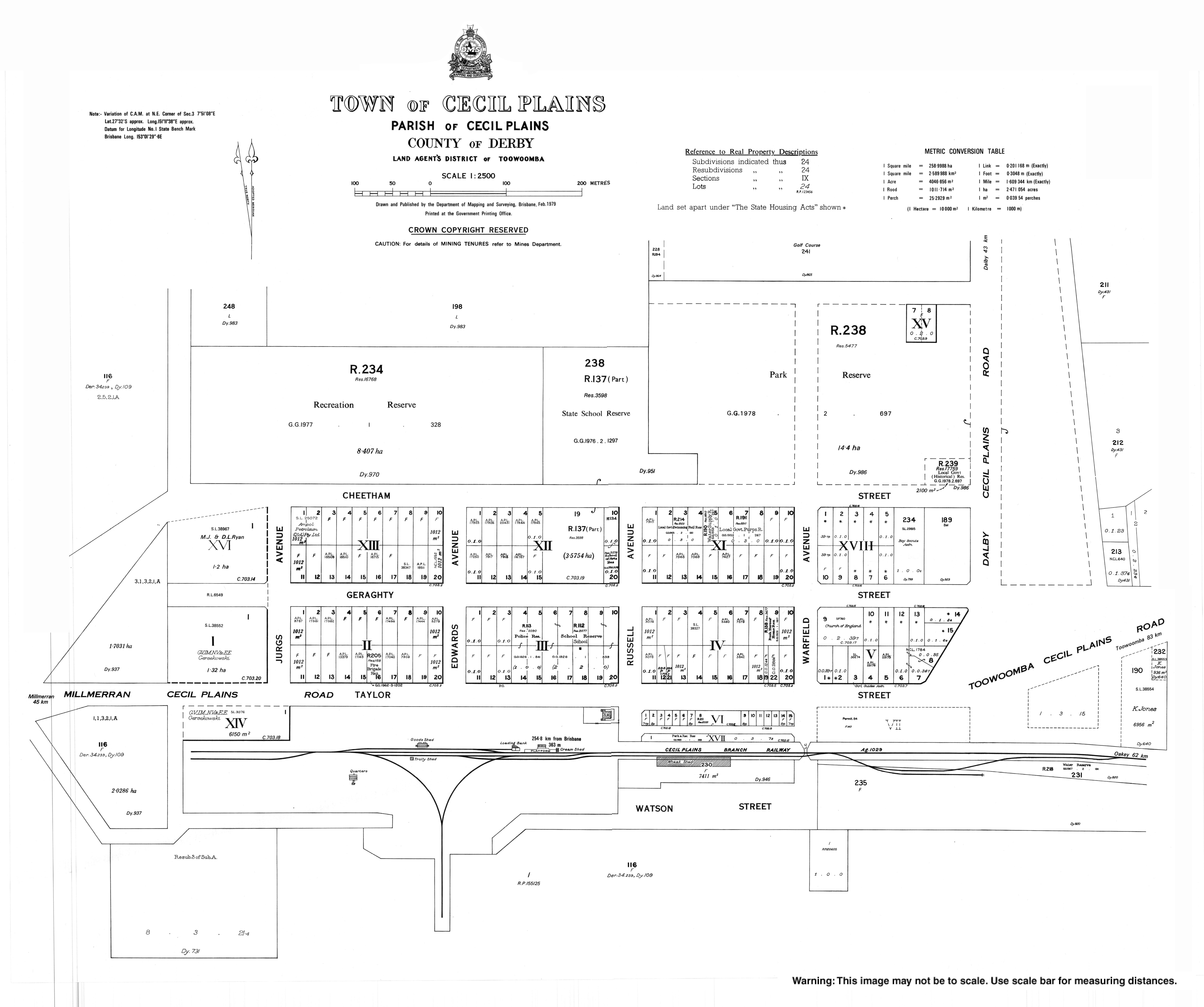
- "Town map of Cecil Plains". Queensland Government. 1979.