Chicago_Road
Territorial Road was the first main road through Michigan, from Detroit to Chicago, Illinois. In the 19th century, it led people from the Eastern United States through Michigan Territory.[2] It was also called the Chicago Road.[3]
| Territorial Road of Michigan | |
|---|---|
| |
| Route information | |
| Length | 200 mi (320 km) |
| Existed | 1830s–present |
| Known for | populating Michigan Territory in the 19th century |
Starting at Michigan Avenue (modern-day US Highway 12) in downtown Detroit, it generally parallels the present-day Interstate 94. The 200-mile (320 km) route runs from Detroit to Ann Arbor, Albion, Marshall, Battle Creek, Paw Paw, and Benton Harbor. In some areas, it is still known as Territorial Road, like Calhoun County.[2]
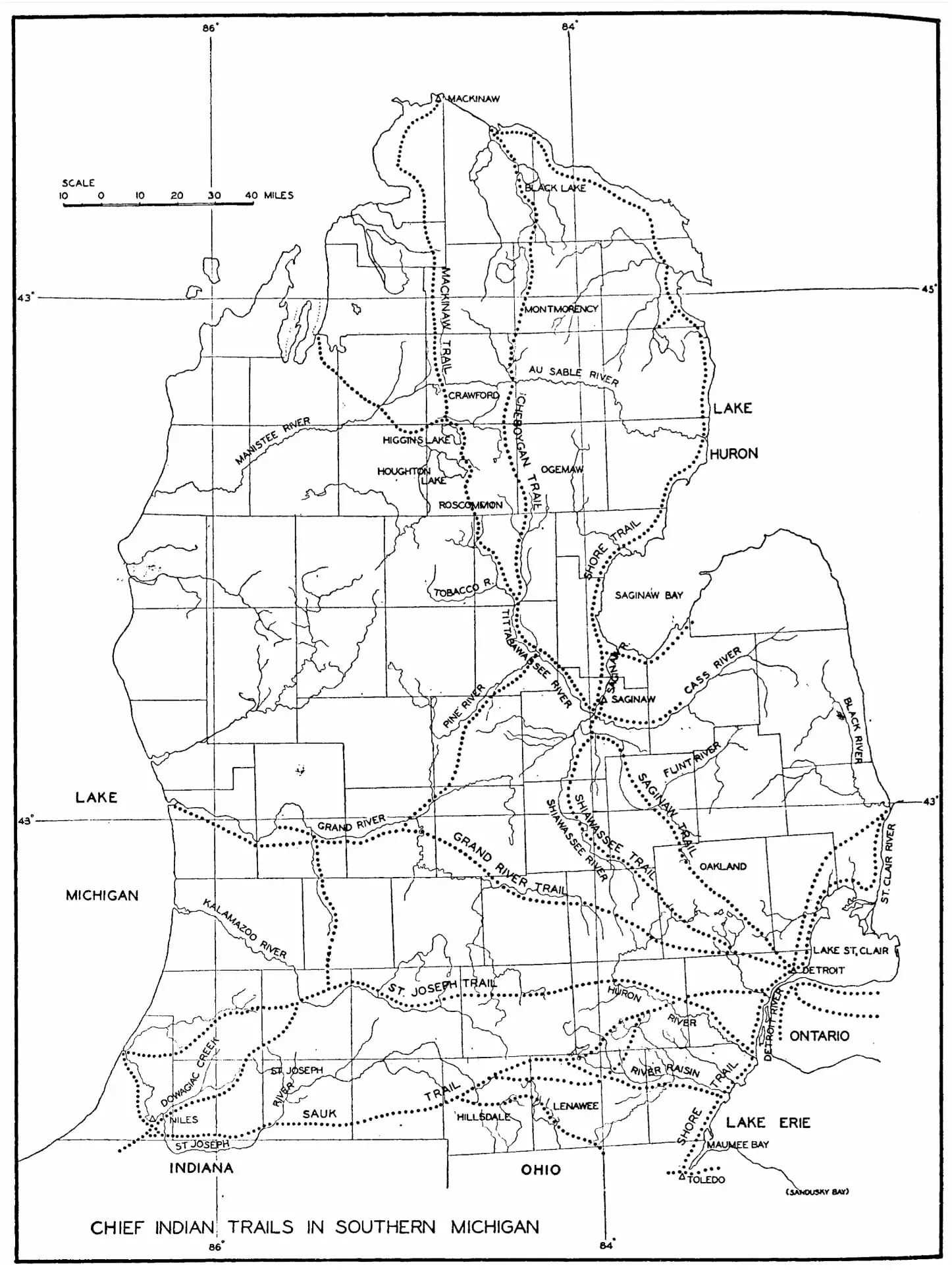
Generally, Michigan's main highways followed trails used by Native Americans for centuries to travel between their villages and hunting and fishing grounds.[4] Native Americans are believed to have lived in Michigan since 11,000 BC.[5] The trails were narrow paths, about 12 to 18 inches (300 to 460 mm) wide, located on high, dry ground along streams and watersheds.[4] Native Americans used dog sleds to move their cargo, a tradition that was followed in Michigan's territorial days, when dogs pulled sleds with mail and cargo on the trails.[5]
The St. Joseph Indian Trail connected with the Great Trail, from Chesapeake Bay on the Atlantic Seaboard to the Mississippi River and the Plains States to the west. The Great Trail connected with Michigan trails from Toledo to Detroit, and up to Lake Huron.[4]
The trails were used by fur traders, explorers, and missionaries to travel into the frontier. The roads were improved and widened for pack horses and settlers.[4] Initially, branches and bushes were cleared, making the trails two to three feet wide to allow room for pack horses. Then, the trails were further widened for oxen-drawn wagons.[4] Federal funds were appropriated to improve the roads, which involved cutting down trees and filling in swampy and low areas. Traveling by wagon was slow, particularly after the roads developed ruts. Later improvements were gravel and then paved roads.[4]
Along the route, local and state historical markers tell of its historical significance.[2] It was initially a path used by Native Americans. It then became a muddy wagon trail.[2] Michigan Territory's legislative council voted to survey land for a route from the east to the west side of the territory in 1829,[6] following the St. Joseph Indian Trail. The road began at Sheldon Inn at the corner of what is now Michigan Avenue and Geddes Road (named for Washtenaw County settlers Robert and John Geddes) and ended at its western-most point at the mouth of the St. Joseph River at Lake Michigan.[7] It was initially called the St. Joseph Road.[4]
Construction of the road began in 1830, when settlers of Eastern Michigan began to use the road. The survey was completed by 1831.[7] Father Gabriel Richard, a delegate to the United States Congress from 1823 to 1825, helped garner support for the road that would facilitate settlement in the state and provide a means for travel between Chicago and Detroit.[8] The federal government provided $20,000 (equivalent to $652,000 in 2023[9]) to upgrade and complete the road,[7] to accommodate the weight of settler's wagons.[10] It was built of logs in a corduroy pattern.[11] It was declared a public highway on May 3, 1831, and soon after began to be called Territorial Road.[10] On May 30, 1834, the road was first used by a stagecoach line. In 1836, it would take three days to travel 80 miles (130 km) from Detroit to Jackson. Inns and taverns were built along the territorial road for travelers' convenience, and the road helped form communities in Wayne, Washtenaw, Jackson, Calhoun, Kalamazoo, Van Buren, and Berrien counties. Michigan Territory's population grew 250% from 1830 to 1840.[7]
Territorial Road was used by General William Henry Harrison and his troops during the War of 1812 to travel between Indiana and Detroit to attack the British in the Siege of Detroit. During World War I, it was designated a military route called the Red Arrow Highway.[12]
Historical markers were located east to west at:
- Geddes Road, just east of the intersection with Michigan Avenue in Canton[7]
- Sheldon's Corner, including Sheldon Inn, on Michigan Avenue just southeast of the intersection of Geddes Road and Michigan Avenue in Canton[3]
- Old Territorial Road historical plaque at Albion, Michigan, installed by the local chapter of the Daughters of the American Revolution (DAR)[10]
- In Jonesville, Michigan, commemorating Father Gabriel Richard for his negotiation of federal funds for the Sauk Trail, part of the Territorial Road[13]
- Territorial Road and the Dodge Tavern, Old US 12, Paw Paw[14]
- In Keeler, also installed by the local DAR
- "Territorial Road Historical Marker". www.hmdb.org. Retrieved August 10, 2023.
- Carlson, Chuck (June 27, 2015). "Biker finds Territorial's a long and winding road". Battle Creek Enquirer. Retrieved March 4, 2022.
- "Sheldon's Corners Historical Marker". Historical Marker Database. Retrieved March 4, 2022.
- Mason, Philip P. (January 12, 1987). "Indians started roads: from paths to freeways" (PDF). Sentinel-Standard. Ionia, Michigan. Archived from the original (PDF) on April 22, 2022. Retrieved March 5, 2022 – via Michigan Department of Transportation.
- "Sled dogs earned their keep in Michigan's earliest years". Lansing State Journal. February 22, 1987. p. 8D. Retrieved March 5, 2022 – via Newspapers.com.
- State of Michigan (1874). Laws of the Territory of Michigan. Vol. 2. W.S. George & Co. p. 744.
Be it enacted by the Legislative Council of the Territory of Michigan, That there shall be a territorial road laid out and established commencing in the Chicago Road, at or near the Inn of Timothy S. Sheldon, in the township of Plymouth, in the county of Wayne, thence west on the most direct and eligible route, through the village of Ann Arbor, by Samuel Clements' to Grand River, where the St. Joseph Trail crosses the same, and also through the Coghwagiac and Grand praries, thence westerly on the most eligible route to, or near the Paw Paw, to the mouth of the St. Joseph River of Lake Michigan...
- "Territorial Road Historical Marker". Historical Marker Database. Retrieved March 4, 2022.
- "Richard, Father Gabriel". Detroit Historical Society. Retrieved March 5, 2022.
- Johnston, Louis; Williamson, Samuel H. (2023). "What Was the U.S. GDP Then?". MeasuringWorth. Retrieved November 30, 2023. United States Gross Domestic Product deflator figures follow the MeasuringWorth series.
- Passic, Frank (June 24, 2007). "Territorial Road". Morning Star. p. 3. Retrieved March 4, 2022 – via www.albionmich.com.
- Meier, Eric. "Construction Project Unearths Oldest Road in Southwest Michigan". WRKR. Retrieved March 4, 2022.
- Wyatt, Ken (October 23, 2010). "Peek through time: St. Joseph Trail played an important part in the settlement of Jackson". Jackson Citizen Patriot. Retrieved March 5, 2022 – via MLive.
- "Father Gabriel Richard". The Historical Marker Database. Retrieved March 5, 2022.
- "Historical Marker - S163 - Territorial Road (Marker ID#:S163)" (PDF). Michigan Department of Natural Resources.