Bridge across the Río Fuerte at El FuerteEl Chepe at terminal station, 8 February 2009
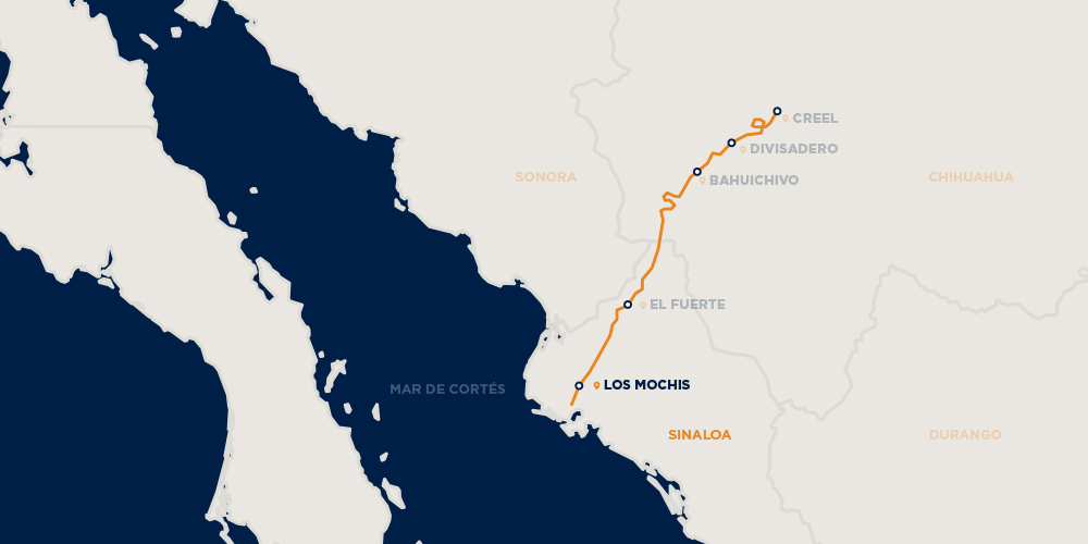
It runs 673km (418mi), traversing the Copper Canyon, a rugged series of canyons that have led some to call this the most scenic railroad trip on the continent. It is both an important transportation system for locals and a draw for tourists.[4]
The tracks pass over 37 bridges and through 86 tunnels, rising as high as 2,400m (7,900ft) above sea level near Divisadero (the continental divide), a popular lookout spot over the canyons.[5] Each one-way trip takes roughly 16 hours. The track also crosses over itself to gain elevation.
The headquarters were in turn located in Mexico City, Chihuahua and Los Mochis.[citation needed]
From 1910 to 1914, Mexico North Western Railway (sp. Ferrocarril del Noroeste) completed the Temosachic-Casas-Grandes line. Kansas City, Mexico and Orient Railway completed the Chihuahua-Ojinaga section.[8]Enrique Creel's Chihuahua al Pacífico railroad completed the Chihuahua-Creel section.[8]
In 1940, the Mexico acquired rights from Kansas City, Mexico and Orient Railway.[8] In May 1952, Mexico took possession of a line operated by Mexican Northwestern Railway.[8] In 1955, Mexico merged them as Ferrocarril Chihuahua al Pacifico, S.A. de C.V.[8]
Financial difficulties caused by the cost of building a railroad through rugged terrain delayed the project, and the ChP was not completed until 1961.[4][1]
The private rail franchise Ferromex took over the railroad from the Mexican government in 1998.[citation needed]
Schedule
In general, two different passenger trains run daily: Chepe Regional, a slower service with more stops for locals, with 15 official stops and more than 50 flag stops at which boardings or disembarkations can be made at passenger request, and the other a luxury, Chepe Express, direct service for tourists, which is faster and more expensive.[5] First-class trains are composed of two to three cars, each holding 64 passengers. Second-class trains have three or four cars, each holding 68 passengers.[5][9]
There is also regular cargo service running between Topolobampo and Chihuahua that might be further increased and extended so as to connect with the Texas Pacifico Transportation Railroad at the OjinagaPresidio Crossing into the United States as a part of the La Entrada al Pacifico.
For a good but slightly dated guide to the railroad and the area, see Wampler, Joseph, "New Rails to Old Towns: The Region and Story of the Ferrocarriles Chihuahua al Pacifico," (1969, Berkeley, CA).
This article uses material from the Wikipedia article Copper_Canyon_Railway, and is written by contributors.
Text is available under a CC BY-SA 4.0 International License; additional terms may apply. Images, videos and audio are available under their respective licenses.

.jpg)
