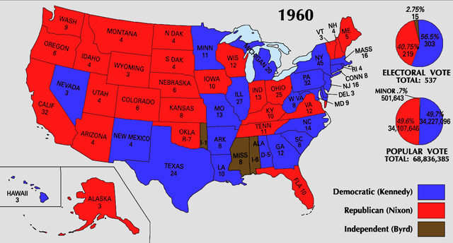
1960_Electoral_Map.png

Size of this preview:
800 × 430 pixels
.
Other resolutions:
320 × 172 pixels
|
640 × 344 pixels
|
1,182 × 635 pixels
.
|
U.S. presidential election maps
from the National Atlas of the United States |
| See also: SVG maps |
| 1789 · 1792 · 1796 · 1800 · 1804 · 1808 · 1812 · 1816 · 1820 · 1824 · 1828 · 1832 · 1836 · 1840 · 1844 · 1848 · 1852 · 1856 · 1860 · 1864 · 1868 · 1872 · 1876 · 1880 · 1884 · 1888 · 1892 · 1896 · 1900 · 1904 · 1908 · 1912 · 1916 · 1920 · 1924 · 1928 · 1932 · 1936 · 1940 · 1944 · 1948 · 1952 · 1956 · 1960 · 1964 · 1968 · 1972 · 1976 · 1980 · 1984 · 1988 · 1992 · 1996 · 2000 · 2004 |
Summary
| Description |
English:
1960 Electoral College Map
|
| Source | https://nationalmap.gov/small_scale/printable/elections.html |
| Author | United States Geological Survey |
Licensing
|
|
This map was obtained from an edition of the
National Atlas of the United States
. Like almost all works of the U.S. federal government, works from the
National Atlas
are in the
public domain
in the United States.
Online access: NationalAtlas.gov | 1970 print edition: Library of Congress , Perry-Castañeda Library
|
|