2010_1128_Wat_Phantao.JPG

Size of this preview:
800 × 503 pixels
.
Other resolutions:
320 × 201 pixels
|
640 × 403 pixels
|
1,024 × 644 pixels
|
1,280 × 805 pixels
|
1,920 × 1,208 pixels
.
Summary
| Description |
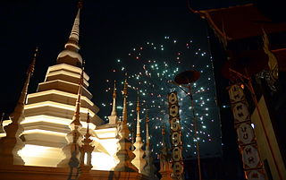
English:
Fireworks explode up in the skies above Chiang Mai on the Sunday after the
Loi Krathong
(locally known as
Yi Peng
) festival. The photo was taken at
Wat Phantao
(Thai script: วัดพันเตา), the wooden temple immediately next to
Wat Chedi Luang
. The fireworks were part of the extended Loi Krathong festivities in Chiang Mai.
|
| Date | |
| Source | Own work |
| Author | Takeaway |
| Camera location |
|
View this and other nearby images on: OpenStreetMap |
|
|---|
Licensing
I, the copyright holder of this work, hereby publish it under the following licenses:
This file is licensed under the
Creative Commons
Attribution-Share Alike 3.0 Unported
license.
-
You are free:
- to share – to copy, distribute and transmit the work
- to remix – to adapt the work
-
Under the following conditions:
- attribution – You must give appropriate credit, provide a link to the license, and indicate if changes were made. You may do so in any reasonable manner, but not in any way that suggests the licensor endorses you or your use.
- share alike – If you remix, transform, or build upon the material, you must distribute your contributions under the same or compatible license as the original.

|
Permission is granted to copy, distribute and/or modify this document under the terms of the GNU Free Documentation License , Version 1.2 or any later version published by the Free Software Foundation ; with no Invariant Sections, no Front-Cover Texts, and no Back-Cover Texts. A copy of the license is included in the section entitled GNU Free Documentation License . |
You may select the license of your choice.