AMH-8133-KB_Floor_plan_of_the_fort_on_Goeree.jpg

Size of this preview:
718 × 600 pixels
.
Other resolutions:
288 × 240 pixels
|
575 × 480 pixels
|
920 × 768 pixels
|
1,226 × 1,024 pixels
|
2,400 × 2,004 pixels
.
Summary
Nederlands: Plattegrond van het fort op Goeree
English: Floor plan of the fort on Goeree( |
|||||||||||||||||||||||||||
|---|---|---|---|---|---|---|---|---|---|---|---|---|---|---|---|---|---|---|---|---|---|---|---|---|---|---|---|
| Author |
Nederlands:
Anoniem / Anonymous (landmeter / kaartenmaker), Awnsham Churchill (uitgever), John Churchill (uitgever)
English:
Anoniem / Anonymous (land surveyor / mapmaker), Awnsham Churchill (publisher), John Churchill (publisher)
|
||||||||||||||||||||||||||
| Title |
Nederlands:
Plattegrond van het fort op Goeree
English:
Floor plan of the fort on Goeree
|
||||||||||||||||||||||||||
| Description |
Nederlands:
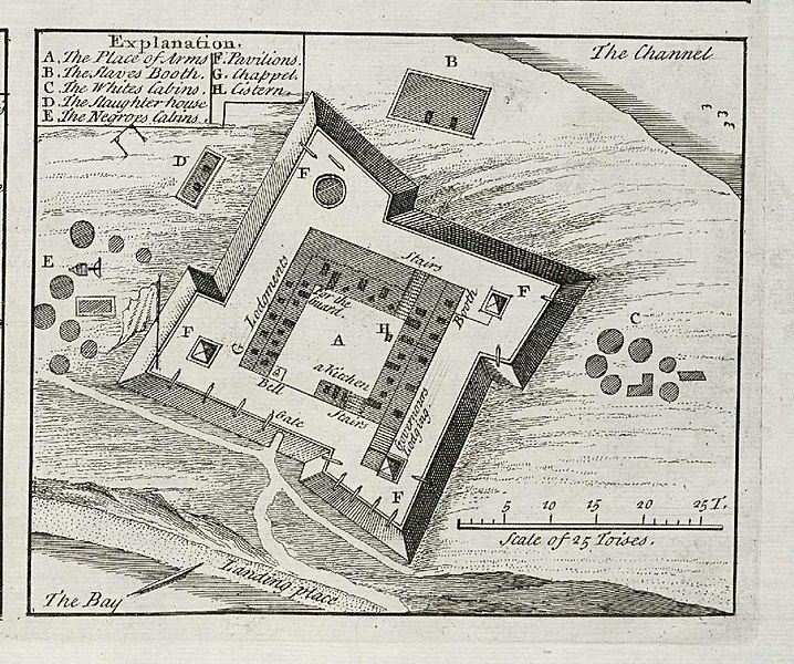
Plattegrond van het fort op Goeree.
Legenda: A-H . Tot 1677 was het eiland Goeree in Nederlandse handen, daarna ging het over naar Frankrijk.
English:
Floor plan of the fort on the island of Goeree.
Key: A-H . Until 1677 the island of Goeree was held by the Dutch, thereafter it went to France. |
||||||||||||||||||||||||||
| Date | 1732 | ||||||||||||||||||||||||||
| Medium |
Nederlands:
gravure op papier
English:
engraving on paper
|
||||||||||||||||||||||||||
| Dimensions | height: 10.5 cm (4.1 in); width: 9 cm (3.5 in) | ||||||||||||||||||||||||||
| Collection |
|
||||||||||||||||||||||||||
| Accession number |
61 B 25, na p. 20
|
||||||||||||||||||||||||||
| Notes |
English:
Subjects
: chart / map / plan, key, fortification, building, ship / vessel
Nederlands:
Onderwerpen
: plattegrond / kaart, legenda, vesting, gebouw, schip / vaartuig
|
||||||||||||||||||||||||||
| Source/Photographer |
|
||||||||||||||||||||||||||
|
Permission
( Reusing this file ) |
|
||||||||||||||||||||||||||

| Object location |
|
View this and other nearby images on: OpenStreetMap |
|
|---|