AT_119587_Jesuitenkirche_Wien_Innenansicht_9234.jpg

Size of this preview:
431 × 600 pixels
.
Other resolutions:
172 × 240 pixels
|
345 × 480 pixels
|
552 × 768 pixels
|
735 × 1,024 pixels
|
1,471 × 2,048 pixels
|
3,433 × 4,779 pixels
.
Summary
| Description |
English:
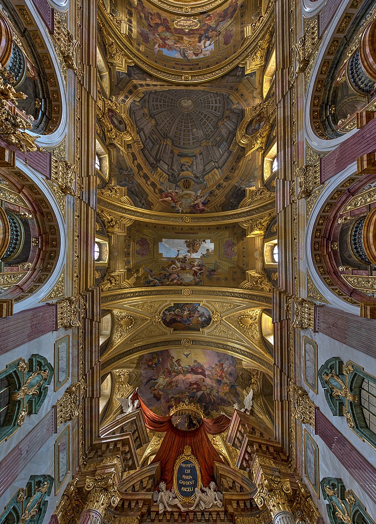
Jesuit Church
, Dr.-Ignaz-Seipel-Platz, Vienna, Frescoes by
Andrea Pozzo
during his time in Vienna (1702-1709).
Deutsch:
Innenansicht der
Jesuitenkirche
, auch Universitätskirche bezeichnet, im 1.
Wiener
Gemeindebezirk
Innere Stadt
.
Die Kirche wurde von 1623 bis 1627 von einem unbekannten Architekten errichtet. Von 1703 bis 1707 wurde der Kirchenbau von dem Jesuiten, Maler und Architekten Andrea Pozzo wesentlich umgebaut und umgestaltet. Unter anderem errichtete er die Türme. Über den acht Seitenkapellen zog er Emporen ein, die miteinander verbunden sind und von geraden und geschwungenen Säulen getragen werden. Er gestaltete auch die Fresken und schuf das Hochaltarbild sowie bis auf eines alle Seitenaltarbilder. Die Deckenfresken wurden 1827 und 1899 überarbeitet.
Français :
Église des Jésuites de Vienne
, Dr.-Ignaz-Seipel-Platz.
Fresques de
Andrea Pozzo
pendant son temps à Vienne (1702-1709)
Italiano:
Chiesa dei Gesuiti
, Dr.-Ignaz-Seipel-Platz, Vienna. Affreschi di
Andrea Pozzo
durante la sua permanenza a Vienna (1702-1709)
|
|||||||
| Date | ||||||||
| Source | Own work | |||||||
| Author |
Hubertl |
|||||||
|
Attribution
( required by the license ) |
© Hubertl / Wikimedia Commons / | |||||||
|
Permission
( Reusing this file ) |
|
_-_H3986.jpg)


| Camera location |
|
View this and other nearby images on: OpenStreetMap |
|
|---|
Licensing
This file is licensed under the
Creative Commons
Attribution-Share Alike 4.0 International
license.
-
You are free:
- to share – to copy, distribute and transmit the work
- to remix – to adapt the work
-
Under the following conditions:
- attribution – You must give appropriate credit, provide a link to the license, and indicate if changes were made. You may do so in any reasonable manner, but not in any way that suggests the licensor endorses you or your use.
- share alike – If you remix, transform, or build upon the material, you must distribute your contributions under the same or compatible license as the original.
|
|
Please do not upload an updated image here without consultation with the Author. The author would like to make corrections only at his own source. This ensures that the changes are preserved.
|

|
|
This image has been assessed using the
Quality image guidelines
and is considered a
Quality image
.
|