Aachen_Germany_Domschatz_Cross-of-Lothair-01.jpg
Summary
|
Cross of Lothair
|
||||||||||||||||||||||||
|---|---|---|---|---|---|---|---|---|---|---|---|---|---|---|---|---|---|---|---|---|---|---|---|---|
| Artist |
Unknown artist
|
_01.jpg)
|
||||||||||||||||||||||
| Title | ||||||||||||||||||||||||
| Part of |
Aachen Cathedral Treasury
|
|||||||||||||||||||||||
| Object type | crux gemmata | |||||||||||||||||||||||
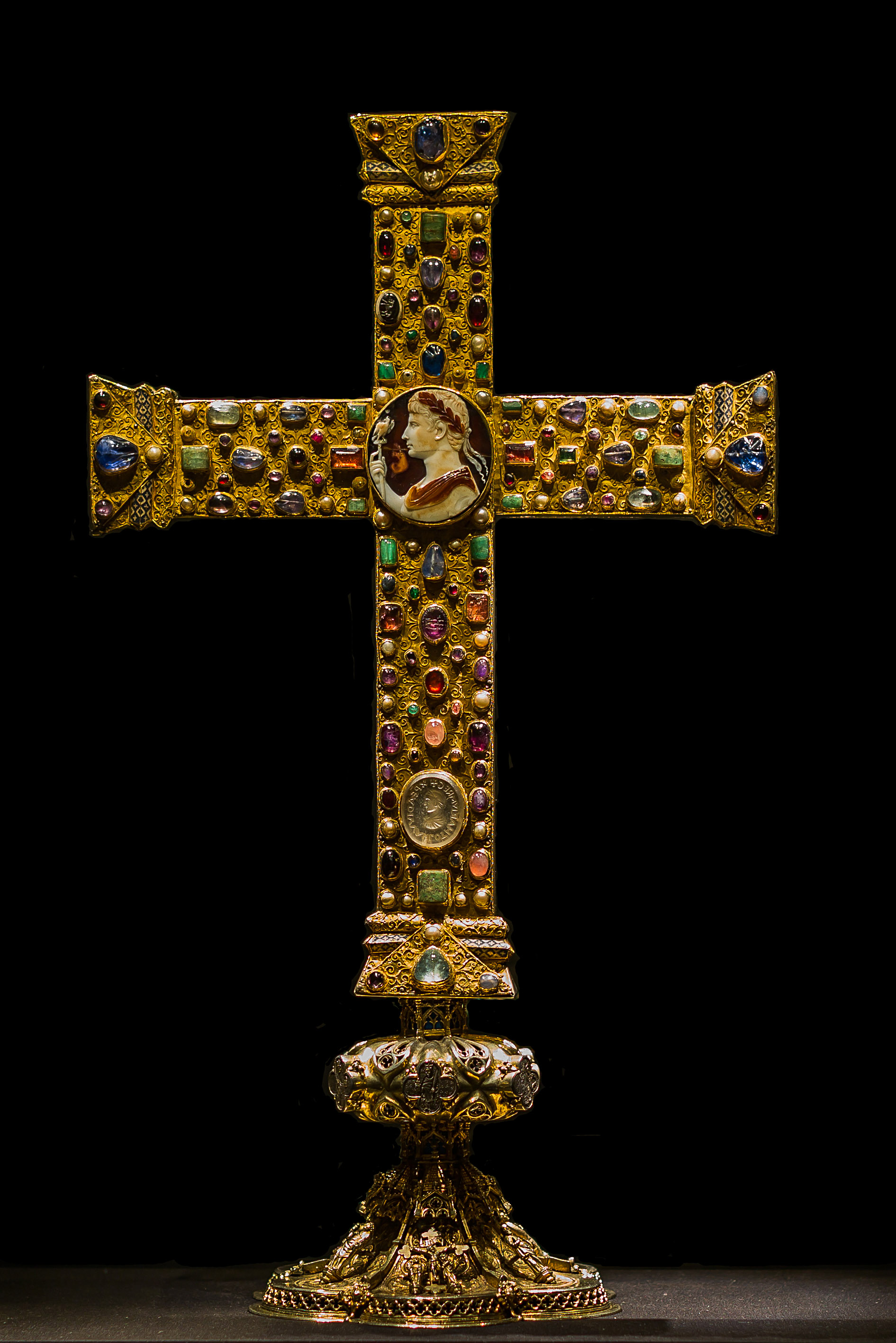
| Description |
English:
The
Cross of Lothair
is a jewelled processional cross, dating about 1000 AD. The cross is a famous part of the
Aachen Cathedral Treasury
at Aachen, Germany
Deutsch:
Lotharkreuz
, ottonisches Gemmen- und Vortragekreuz um 1000 (teils auch früher datiert), Aachener Domschatzkammer
|
|||||||||||||||||||||||
| Date | early 10 th century | |||||||||||||||||||||||
| Dimensions | height: 50 cm (19.6 in); width: 38.5 cm (15.1 in); depth: 2.3 cm (0.9 in) | |||||||||||||||||||||||
| Collection |
|
|||||||||||||||||||||||
| Current location |
ground floor
|
|||||||||||||||||||||||
| Object location |
|
|||||||||||||||||||||||
| Place of creation | Cologne ? , Germany | |||||||||||||||||||||||
| Authority file | ||||||||||||||||||||||||
| Source/Photographer | Self-photographed : Taken on 3 August 2014 / CEphoto, Uwe Aranas | |||||||||||||||||||||||
|
Permission
( Reusing this file ) |
|
|||||||||||||||||||||||
| Other versions |
|
|||||||||||||||||||||||


| Camera location |
|
View this and other nearby images on: OpenStreetMap |
|
|---|
|
|
Do not upload new revisions over this file version without my explicit consent. Instead, use the possibility to upload a new version under a new name and tag it as a
derivate
or
extract
of this file.
|

Licensing
-
You are free:
- to share – to copy, distribute and transmit the work
- to remix – to adapt the work
-
Under the following conditions:
- attribution – You must give appropriate credit, provide a link to the license, and indicate if changes were made. You may do so in any reasonable manner, but not in any way that suggests the licensor endorses you or your use.
- share alike – If you remix, transform, or build upon the material, you must distribute your contributions under the same or compatible license as the original.

|
Permission is granted to copy, distribute and/or modify this document under the terms of the GNU Free Documentation License , Version 1.2 or any later version published by the Free Software Foundation ; with no Invariant Sections, no Front-Cover Texts, and no Back-Cover Texts. A copy of the license is included in the section entitled GNU Free Documentation License . |
|
|
This image has been assessed using the
Quality image guidelines
and is considered a
Quality image
.
|