Absenceblacks.png
No higher resolution available.

|
This
ethnographic map
image could be re-created
using
vector graphics
as an
SVG
file
. This has several advantages; see
Commons:Media for cleanup
for more information. If an SVG form of this image is available, please upload it and afterwards replace this template with
{{

vector version available

|

new image name

}}
.
It is recommended to name the SVG file “Absenceblacks.svg”—then the template Vector version available (or Vva ) does not need the new image name parameter. |
Summary
| Description |
English:
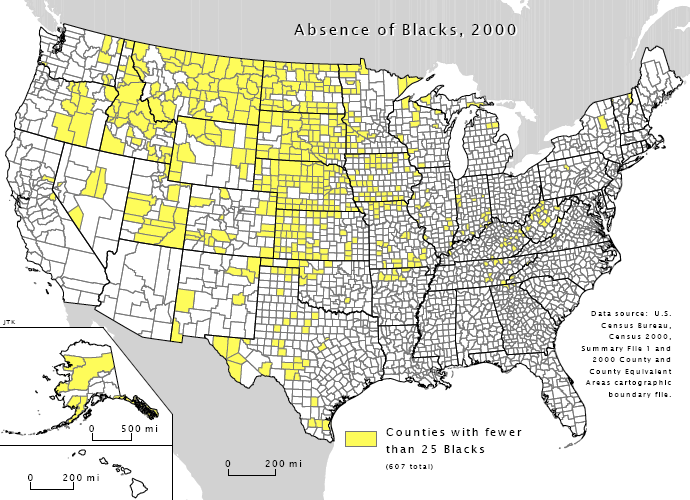
Map indicating U.S. counties with fewer than 25
black
or
African-American
inhabitants. Image as based on the
census 2000
by the U.S. Census Bureau.
Badagnani
(
talk
) 08:49, 23 May 2009 (UTC)
|
| Source | US gov |
| Author | US gov |
Licensing
|
|
This image or file is a work of a
United States Census Bureau
employee, taken or made as part of that person's official duties. As a
work
of the
U.S. federal government
, the image is in the
public domain
.
|

|
Original upload log
The original description page was
here
. All following user names refer to en.wikipedia.
| Date/Time | Dimensions | User | Comment |
|---|---|---|---|
| 2010-07-29 17:59 | 690×500× (259680 bytes) | Beao | |
| 2009-05-23 08:49 | 696×506× (180516 bytes) | Badagnani | ==Summary== Map indicating U.S. counties with fewer than 25 [[Black people|black]] or [[African American]] inhabitants. Image as based on the [http://www.valpo.edu/geomet/pics/geo200/no_blacks.pdf census 2000] by the U.S. Census Bureau. ~~~~ ==Licensing= |