Afghanistan_region_during_500_BC.jpg


Description
Español: Mapa histórico del Imperio Aqueménida.
English: Historic map of the Achaemenid Empire
Français : Carte historique de l'empire achéménide
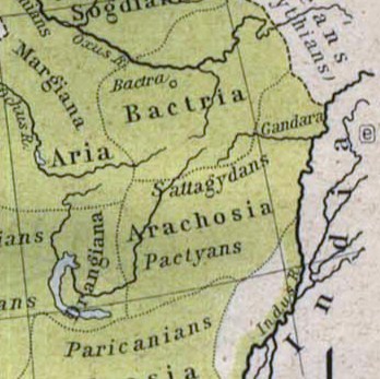
Arachosia , Aria and Bactria were the ancient satraps of the Persian Achaemenid Empire that made up most of what is now Afghanistan and western Pakistan during 500 B.C. The main inhabitants of Arachosia were known as Pactyans , whose name possibly survives in today's Pakhtuns .
Date
Source

http://www.lib.utexas.edu/maps/historical/history_asia.html

http://www.lib.utexas.edu/maps/historical/shepherd/persian_empire.jpg
Author William R. Shepherd (b. 1871 - d. 1934)
Permission
( Reusing this file )
Public domain

This work is in the public domain in its country of origin and other countries and areas where the copyright term is the author's life plus 70 years or fewer .


You must also include a United States public domain tag to indicate why this work is in the public domain in the United States. Note that a few countries have copyright terms longer than 70 years: Mexico has 100 years, Jamaica has 95 years, Colombia has 80 years, and Guatemala and Samoa have 75 years. This image may not be in the public domain in these countries, which moreover do not implement the rule of the shorter term . Honduras has a general copyright term of 75 years, but it does implement the rule of the shorter term. Copyright may extend on works created by French who died for France in World War II ( more information ), Russians who served in the Eastern Front of World War II (known as the Great Patriotic War in Russia) and posthumously rehabilitated victims of Soviet repressions ( more information ).

Other versions File:Map of the Achaemenid Empire.jpg (full)

Captions

Add a one-line explanation of what this file represents

Items portrayed in this file

depicts

image/jpeg

b4c7eb3a6331a88f235720771aa4cb7956e30af9

57,525 byte

347 pixel

348 pixel