Albuquerque_pano_sunset.jpg

Size of this preview:
800 × 116 pixels
.
Other resolutions:
320 × 46 pixels
|
640 × 92 pixels
|
1,024 × 148 pixels
|
1,280 × 185 pixels
|
2,560 × 370 pixels
|
20,779 × 3,000 pixels
.
Summary
| Warning | The original file is very high-resolution. It might not load properly or could cause your browser to freeze when opened at full size. |
|---|
|
|
This image has been assessed using the
Quality image guidelines
and is considered a
Quality image
.
|
| Camera location |
|
View this and other nearby images on: OpenStreetMap |
|
|---|
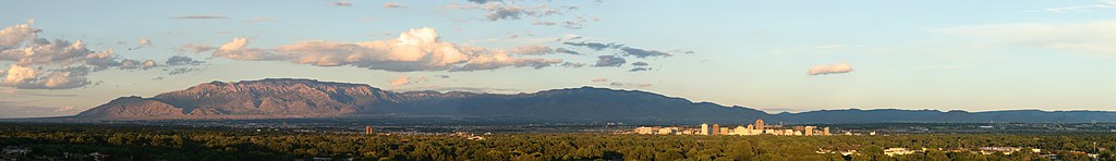
| Description |
Deutsch:
Albuquerque und die Sandia Mountains bei Sonnenuntergang
English:
Albuquerque and Sandia Mountains at sunset
This image was created with
Hugin
.
|
| Date | |
| Source | Own work |
| Author | Daniel Schwen |
| Other versions |
Derivative works of this file: Alb Skyline.png 
|
Licensing
I, the copyright holder of this work, hereby publish it under the following license:
This file is licensed under the
Creative Commons
Attribution-Share Alike 4.0 International
license.
-
You are free:
- to share – to copy, distribute and transmit the work
- to remix – to adapt the work
-
Under the following conditions:
- attribution – You must give appropriate credit, provide a link to the license, and indicate if changes were made. You may do so in any reasonable manner, but not in any way that suggests the licensor endorses you or your use.
- share alike – If you remix, transform, or build upon the material, you must distribute your contributions under the same or compatible license as the original.