Alemannic-Dialects-Map-English.png
Size of this preview:
800 × 571 pixels
.
Other resolutions:
320 × 229 pixels
|
640 × 457 pixels
|
1,024 × 731 pixels
|
1,400 × 1,000 pixels
.
| Description |
English:
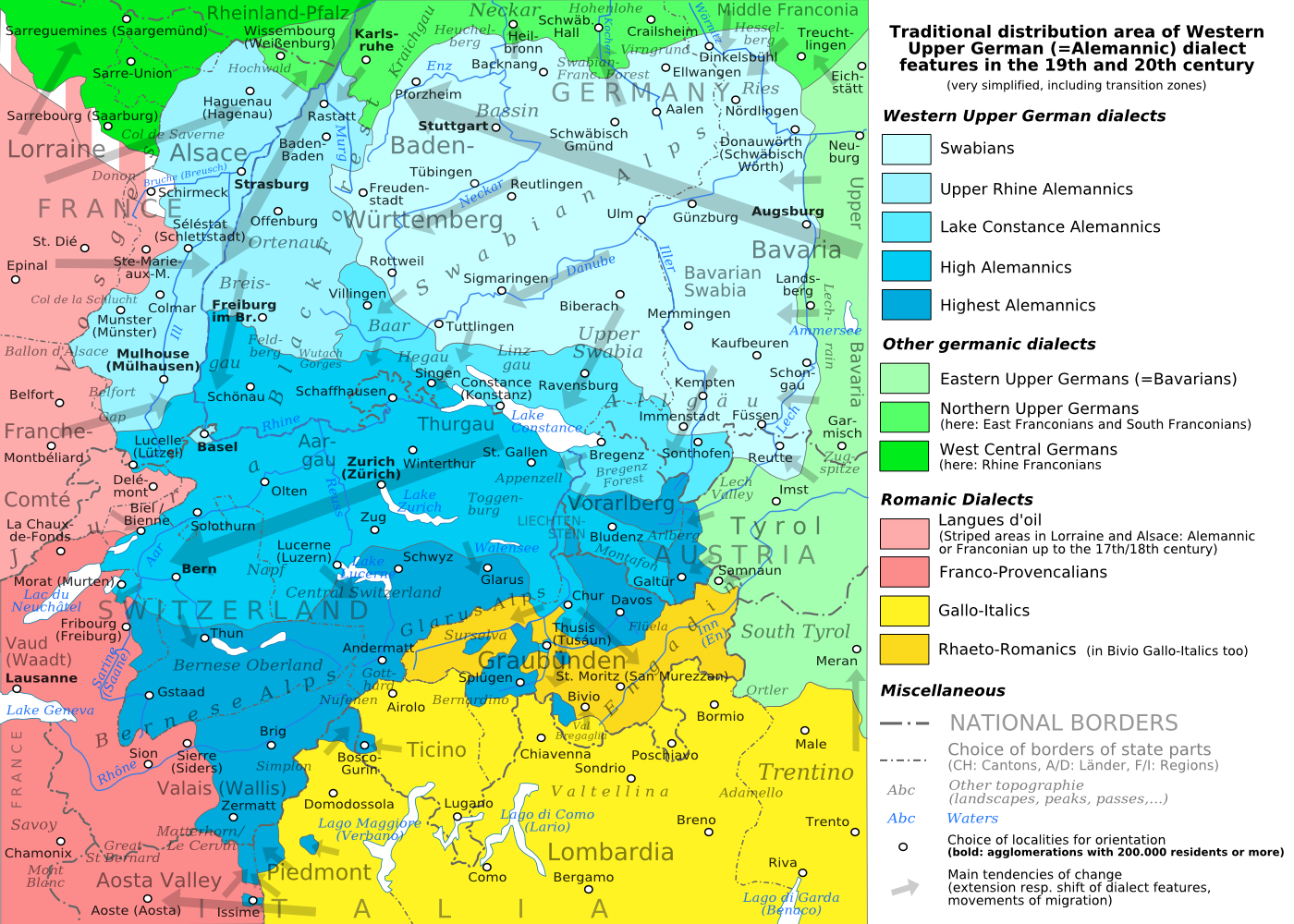
The traditional distribution area of the western upper German (=alemannic) dialects in the 19th and 20th century. Source: Mainly these articles in the German wikipedia: *
Alemannische Dialekte
*
Grenzorte des alemannischen Dialektraums
*
Traditionell rätoromanischsprachiges Gebiet Graubündens
and *
Sprachen und Dialekte in der Region Elsass
, plus the (newer) literature, which is mentioned there. This area, having been quite stable for at least some 300 years up to the 19th century, saw consecutively more or less strong changes by industrialisation, population growth, migrations and political developments.
Deutsch:
Das traditionelle Verbreitungsgebiet der westoberdeutschen (=alemannischen) Dialekte im 19. und 20. Jahrhundert. Grundlage: vor allem diese Artikel der deutschsprachigen Wikipedia: *
Alemannische Dialekte
*
Grenzorte des alemannischen Dialektraums
*
Traditionell rätoromanischsprachiges Gebiet Graubündens
und *
Sprachen und Dialekte in der Region Elsass
, sowie die dort jeweils genannte (jüngere) Literatur. Das bis ins 19. Jahrhundert für mindestens etwa 300 Jahre stabile Gebiet erfuhr nachfolgend durch Industrialisierung, Bevölkerungszuwächse und -bewegungen sowie politische Entwicklungen mehr oder weniger starke Änderungen.
Français :
Le secteur de distribution traditionnel des dialectes allemands supérieurs occidentaux (=alémannique) au 19e et 20e siècle. Source : Principalement ces articles dans le wikipedia allemand : *
Alemannische Dialekte
*
Grenzorte des alemannischen Dialektraums
*
Traditionell rätoromanischsprachiges Gebiet Graubündens
et *
Sprachen und Dialekte in der Region Elsass
, plus la littérature (plus jeune), qui est mentionnée là. Ce secteur, après avoir été stable jusqu'au 19e siècle pour au moins environ 300 années, scie consécutivement des changements plus ou moins forts par industrialisation, croissance démographique, migrations et développements politiques.
Italiano:
Area di distribuzione storica delle varianti linguistiche alto-tedesche occidentali(alemanniche) nel diciannovesimo e ventesimo secolo. Fonti: questa mappa si basa prevalentemente sui seguenti articoli in Wikipedia di lingua tedesca: *
Alemannische Dialekte
*
Grenzorte des alemannischen Dialektraums
*
Traditionell rätoromanischsprachiges Gebiet Graubündens
and *
Sprachen und Dialekte in der Region Elsass
, in aggiunta alla letteratura più recente menzionata in quegli articoli. Questa area, dopo essere rimasta piuttosto stabile per circa trecento anni fino all'inizio del diciannovesimo secolo, ha poi visto trasformazioni di diversa intensità causate dall'industrializzazione, dalla crescita demografica, dai processi migratori e dagli sviluppi politici.
|
| Date | (UTC) |
| Source | |
| Author |
|
| Other versions |
PNG :
PNG :
SVG :
SVG : SVG :
|


|
|
This is a
retouched picture
, which means that it has been digitally altered from its original version. Modifications:
PNG-Version
. The original can be viewed here:
Alemannic-Dialects-Map-English.svg
:
|
I, the copyright holder of this work, hereby publish it under the following licenses:
This file is licensed under the
Creative Commons
Attribution-Share Alike
3.0 Unported
,
2.5 Generic
,
2.0 Generic
and
1.0 Generic
license.
-
You are free:
- to share – to copy, distribute and transmit the work
- to remix – to adapt the work
-
Under the following conditions:
- attribution – You must give appropriate credit, provide a link to the license, and indicate if changes were made. You may do so in any reasonable manner, but not in any way that suggests the licensor endorses you or your use.
- share alike – If you remix, transform, or build upon the material, you must distribute your contributions under the same or compatible license as the original.

|
Permission is granted to copy, distribute and/or modify this document under the terms of the GNU Free Documentation License , Version 1.2 or any later version published by the Free Software Foundation ; with no Invariant Sections, no Front-Cover Texts, and no Back-Cover Texts. A copy of the license is included in the section entitled GNU Free Documentation License . |
You may select the license of your choice.
Original upload log
This image is a derivative work of the following images:
-
File:Alemannic-Dialects-Map-English.svg
licensed with Cc-by-sa-3.0,2.5,2.0,1.0, GFDL
- 2010-08-11T20:11:45Z Testtube 1400x1000 (482460 Bytes) Bugfix
- 2010-08-11T19:44:48Z Testtube 1400x1000 (482811 Bytes) Bugfix
- 2010-08-11T15:14:04Z Testtube 1400x1000 (482540 Bytes) {{Information |Description={{en|1=The traditional distribution area of the western upper german (=alemannic) dialects in the 19th and 20th century. Source: Mainly these articles in the german wikipedia: * [http://de.wikipedi
Uploaded with derivativeFX