|
Description
Ancient Khorasan highlighted.jpg
|
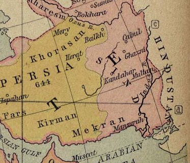
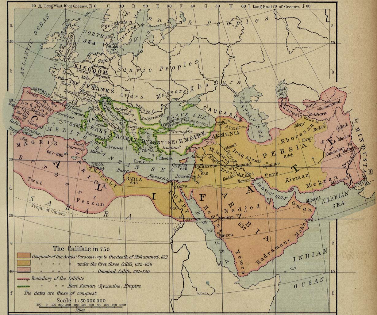
Map showing Ancient Persia in light yellowish and the the land called
Sind
(
most of today's
Afghanistan
and part of
Pakistan
) in pinkish.
A number of ancient references are made to the names shown in this map.
Ibn Batutta
writes in 1333 AD:
[1]
We travelled from there to Naysabur, one of the four capitals of Khurasan.... We travelled thence to Parwan, where I met the amir Buruntayh. He treated me well and wrote to his representatives at
Ghazna
enjoining them to show me honour. We went on to the village of Charkh [Charikar], it being now summer, and from there to the town of Ghazna. This is the town of the famous warrior-sultan Mahmud ibn Sabuktagin, one of the greatest of rulers, who made frequent raids into
India
and captured cities and fortresses there. His grave is in this city and is surmounted by a hospice. The greater part of the town is in ruins and nothing but a fraction of it remains, though it was once a large city. It has an exceedingly cold climate, and the inhabitants move from it in the cold season to
Qandahar
, a large and prosperous town three nights journey from Ghazna, but I did not visit it. We travelled on to
Kabul
, formerly a vast town, the site of which is now occupied by a village inhabited by a tribe of Persians called
Afghans
. They hold mountains and defiles and possess considerable strength, and are mostly highwaymen. Their principle mountain is called Kuh Sulayman... From Kabul we rode to Karmash, which is a fortress belonging to the Afghans... On reaching Sind I followed this practice and bought horses, camels, white slaves and other goods from the merchants. I had already bought from an Iraqi merchant in Ghazna about thirty horses and a camel with a load of arrows, for this is one of the things presented to the sultan. This merchant went off to Khurasan and on returning to India received his money from me. After crossing the
river of Sind
called Panj Ab, our way led through a forrest of reeds, in which I saw a rhinoceros for the first time. After two days' march we reached Janani, a large and fine town on the bank of the river Sind. Its people are a people called the Samira, whose ancestors established themselves there on the conquest of Sind in the time of al-Hajjaj [712 A.D.]
|
Permission
(
Reusing this file
)
|
|
Public domain
Public domain
false
false
|

|
This work is in the
public domain
in its country of origin and other countries and areas where the
copyright term
is the author's
life plus 70 years or fewer
.
 You must also include a
United States public domain tag
to indicate why this work is in the public domain in the United States. Note that a few countries have copyright terms longer than 70 years: Mexico has 100 years, Jamaica has 95 years, Colombia has 80 years, and Guatemala and Samoa have 75 years. This image may
not
be in the public domain in these countries, which moreover do
not
implement the
rule of the shorter term
. Honduras has a general copyright term of 75 years, but it
does
implement the rule of the shorter term. Copyright may extend on works created by French who died for France in
World War II
(
more information
), Russians who served in
the Eastern Front of World War II
(known as the Great Patriotic War in Russia) and posthumously
rehabilitated
victims of Soviet repressions (
more information
).
You must also include a
United States public domain tag
to indicate why this work is in the public domain in the United States. Note that a few countries have copyright terms longer than 70 years: Mexico has 100 years, Jamaica has 95 years, Colombia has 80 years, and Guatemala and Samoa have 75 years. This image may
not
be in the public domain in these countries, which moreover do
not
implement the
rule of the shorter term
. Honduras has a general copyright term of 75 years, but it
does
implement the rule of the shorter term. Copyright may extend on works created by French who died for France in
World War II
(
more information
), Russians who served in
the Eastern Front of World War II
(known as the Great Patriotic War in Russia) and posthumously
rehabilitated
victims of Soviet repressions (
more information
).
|
|
This file has been identified as being free of known restrictions under copyright law, including all related and neighboring rights.
|
https://creativecommons.org/publicdomain/mark/1.0/
PDM
Creative Commons Public Domain Mark 1.0
false
false
|