Ancient_colonies.PNG

Size of this preview:
800 × 400 pixels
.
Other resolutions:
320 × 160 pixels
|
640 × 320 pixels
|
1,024 × 512 pixels
|
1,280 × 639 pixels
|
2,500 × 1,249 pixels
.
Summary
| Description |
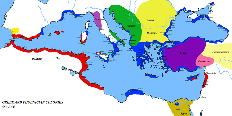
English:
Map of the colonies of
Ancient Greece
and
Phoenicia
— circa
550 BCE
.
|
| Date | 1 March 2008 (original upload date) |
| Source | Own work ( Original text: self-made ) |
| Author | Javierfv1212 ( talk ) |
| Other versions | العربيَّة |
Licensing
|
|
This work has been released into the
public domain
by its author,
Javierfv1212
at
English Wikipedia
. This applies worldwide.
In some countries this may not be legally possible; if so: Javierfv1212 grants anyone the right to use this work for any purpose , without any conditions, unless such conditions are required by law. |
Original upload log
Transferred from en.wikipedia to Commons by Javierfv1212 .
The original description page was
here
. All following user names refer to en.wikipedia.
- 2008-03-08 15:09 Megistias 2500×1249× (768071 bytes) == Summary == {{Information |Description=Greek and Phoenecian colonies about 550 bc |Source=self-made |Date= |Location= |Author=[[User:Javierfv1212|Javierfv1212]] ([[User talk:Javierfv1212|talk]]),Modified by [[User:Megistias]] in the illyrian,thracian,gr
- 2008-03-01 03:09 Javierfv1212 2500×1249× (819010 bytes) {{Information |Description=Greek and Phoenecian colonies about 550 bc |Source=self-made |Date= |Location= |Author=~~~ |other_versions= }}