AndalusAndMorocco.png
No higher resolution available.
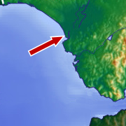
Image cropped from en:Image:Spain_topo.jpg - The arrow points to the mouth of the Guadalquivir river delta and Sanlúcar de Barrameda , where Ferdinand Magellan stayed in 1520. The upper part of the image is Andalusia ; the lower part of the image is Morocco . Gibraltar lies to the east, on Strait of Gibraltar , which divides Andalusia from Morocco.
Source: en:Image:AndalusAndMorocco.png
Uploaded by: en:User:Rapomon

|
Permission is granted to copy, distribute and/or modify this document under the terms of the GNU Free Documentation License , Version 1.2 or any later version published by the Free Software Foundation ; with no Invariant Sections, no Front-Cover Texts, and no Back-Cover Texts. A copy of the license is included in the section entitled GNU Free Documentation License . |
|
|
This file is licensed under the Creative Commons Attribution-Share Alike 3.0 Unported license. | |
|
||
| This licensing tag was added to this file as part of the GFDL licensing update . |
|
|
This file is in the public domain in the United States because it was solely created by NASA . NASA copyright policy states that "NASA material is not protected by copyright unless noted ". (See Template:PD-USGov , NASA copyright policy page or JPL Image Use Policy .) |
|

|
Warnings:
|

|
This
map
image could be re-created
using
vector graphics
as an
SVG
file
. This has several advantages; see
Commons:Media for cleanup
for more information. If an SVG form of this image is available, please upload it and afterwards replace this template with
{{

vector version available

|

new image name

}}
.
It is recommended to name the SVG file “AndalusAndMorocco.svg”—then the template Vector version available (or Vva ) does not need the new image name parameter. |