Antarctic_Peninsula,_the_Larsen_Ice_Shelf,_and_the_sea_ice_covered_waters_around_the_region.jpg

Size of this preview:
468 × 599 pixels
.
Other resolutions:
187 × 240 pixels
|
375 × 480 pixels
|
600 × 768 pixels
|
800 × 1,024 pixels
|
1,600 × 2,048 pixels
|
5,000 × 6,400 pixels
.
Summary
| Description |
English:
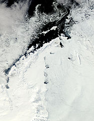
Clear view of the Antarctic Peninsula, the
Larsen Ice Shelf
, and the sea ice covered waters around the region. The Peninsula stands out as the raised terrain amidst the
ice
from the lower left to upper middle of the image.
|
| Date | |
| Source | NASA Earth Observatory |
| Author | Jeff Schmaltz |
Image captured by the Moderate Resolution Imaging Spectroradiometer (MODIS) on NASA’s Aqua satellite. NASA image provided courtesy of the MODIS Rapid Response team.
Licensing
|
|
This file is in the public domain in the United States because it was solely created by NASA . NASA copyright policy states that "NASA material is not protected by copyright unless noted ". (See Template:PD-USGov , NASA copyright policy page or JPL Image Use Policy .) |
|

|
Warnings:
|
| Annotations | This image is annotated: View the annotations at Commons |