Arctic_Ocean_-_en.png
Summary
|
|
This file is an
original
and
may
be
obsolete
for general use, but is kept for historical or archival use. As such, it should not be modified or deleted except to correct upload or technical errors.
Any modified versions or replacements of this image should be uploaded with a different file name.
Information about this file: 2004 version العربيَّة ∙ čeština ∙ Deutsch ∙ English ∙ español ∙ فارسی ∙ français ∙ magyar ∙ italiano ∙ 日本語 ∙ Lëtzebuergesch ∙ македонски ∙ മലയാളം ∙ Nederlands ∙ português ∙ русский ∙ slovenščina ∙ svenska ∙ 简体中文 ∙ 繁體中文 ∙ 正體中文(臺灣) ∙ +/− |
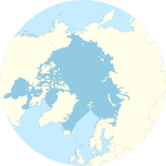
| Description Arctic Ocean - en.png | Arctic Ocean map with English captions showing the North Pole |
| Date | |
| Source | CIA World Factbook ( https://www.cia.gov/library/publications/the-world-factbook/geos/xq.html ) |
| Author | CIA |
| Other versions | Slovene version: Image:Arctic Ocean-sl.png |
Licensing
| Public domain Public domain false false |
|
|
This image is in the
public domain
because it contains materials that originally came from the United States
Central Intelligence Agency
's
World Factbook
.
Bahasa Indonesia ∙ čeština ∙ Deutsch ∙ eesti ∙ English ∙ español ∙ Esperanto ∙ français ∙ galego ∙ hrvatski ∙ italiano ∙ Nederlands ∙ norsk nynorsk ∙ polski ∙ português ∙ sicilianu ∙ slovenščina ∙ suomi ∙ Türkçe ∙ Zazaki ∙ беларуская (тарашкевіца) ∙ македонски ∙ русский ∙ српски / srpski ∙ українська ∙ ქართული ∙ বাংলা ∙ தமிழ் ∙ മലയാളം ∙ 한국어 ∙ 日本語 ∙ 中文 ∙ 中文(简体) ∙ 中文(繁體) ∙ العربية ∙ +/− |

|

|
File:Arctic Ocean SVG.svg
is a vector version of this file. It should be used in place of this PNG file when not inferior.
File:Arctic Ocean - en.png →
File:Arctic Ocean SVG.svg
For more information, see
Help:SVG
.
|
Captions
A map of the Arctic Ocean around the north pole, with borders as delineated by the International Hydrographic Organization (IHO), including Hudson Bay (some of which is south of 57°N latitude, off the map)".
বিশ্বের ক্ষুদ্রতম মহাসাগর


