Atlas_Van_der_Hagen-KW1049B12_017-PORTUGALLIAE_et_ALGARBIAE_REGNA.jpeg
Size of this preview:
724 × 599 pixels
.
Other resolutions:
290 × 240 pixels
|
580 × 480 pixels
|
928 × 768 pixels
|
1,237 × 1,024 pixels
|
2,474 × 2,048 pixels
|
5,500 × 4,553 pixels
.
Summary
|
Dirk Jansz van Santen
:
Atlas van Dirk van der Hagen (volledig, collectie KB)
|
||||||||||||||||||||||||||||||||||||||||||||||||||||
|---|---|---|---|---|---|---|---|---|---|---|---|---|---|---|---|---|---|---|---|---|---|---|---|---|---|---|---|---|---|---|---|---|---|---|---|---|---|---|---|---|---|---|---|---|---|---|---|---|---|---|---|---|
| Artist |
Author: Nicolaes Visscher II Publisher:
|

|
||||||||||||||||||||||||||||||||||||||||||||||||||
| Author |
Author: Nicolaes Visscher II Publisher:
|
|||||||||||||||||||||||||||||||||||||||||||||||||||
| Title |
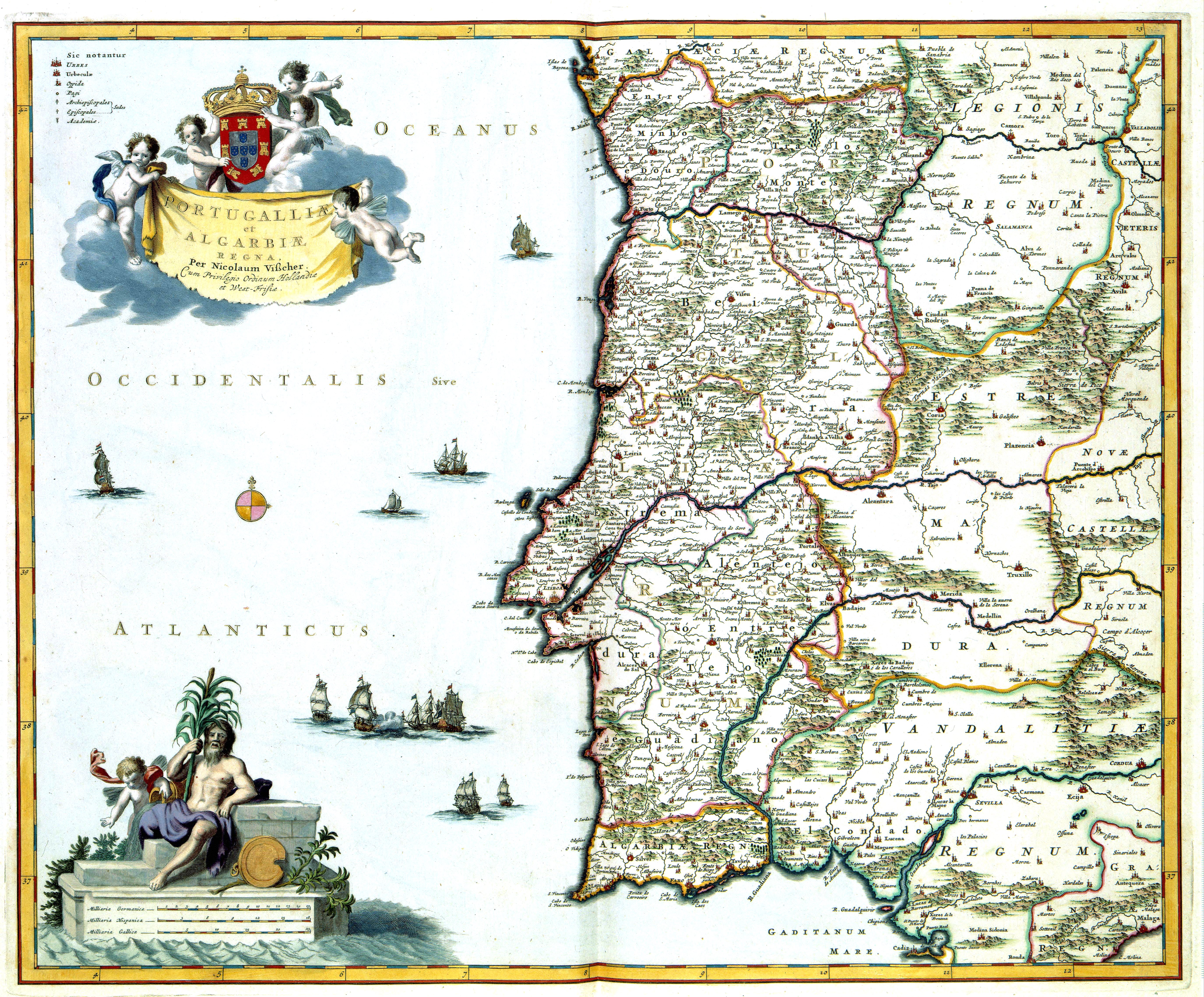
PORTUGALLIAE et ALGARBIAE REGNA
|
|||||||||||||||||||||||||||||||||||||||||||||||||||
| Object type | map | |||||||||||||||||||||||||||||||||||||||||||||||||||
| Description |
Nederlands:
Deze kaart van Portugal werd in de tachtiger jaren van de 17de eeuw uitgegeven door
Nicolaes Visscher II
(1649-1702). Als bron gebruikte Visscher zeer waarschijnlijk een kaart van de Portugese kartograaf Pedro Texeira Albernaz (overleden 1662) die in 1662 een grote overzichtskaart van Portugal publiceerde. Zijn kaart vormde meer dan honderd jaar het prototype voor talrijke kaarten van het koninkrijk.
English:
Map of Portugal, published in the eighties of the 17th century by
Nicolaes Visscher II
(1649-1702). It is probably based on a map of the cartographer Pedro Texeira Albernaz (died 1662), who published a general map of Portugal in 1662. His map was used more than a hundred years as a source for many maps of the kingdom.
|
|||||||||||||||||||||||||||||||||||||||||||||||||||
| Language |
Dutch
|
|||||||||||||||||||||||||||||||||||||||||||||||||||
| Date | after 1681 | |||||||||||||||||||||||||||||||||||||||||||||||||||
| Publication date |
circa
|
|||||||||||||||||||||||||||||||||||||||||||||||||||
| Medium |
Nederlands:
kopergravure
English:
copper engraving print
|
|||||||||||||||||||||||||||||||||||||||||||||||||||
| Dimensions | 47 x 56 cm | |||||||||||||||||||||||||||||||||||||||||||||||||||
| Collection |
|
|||||||||||||||||||||||||||||||||||||||||||||||||||
| Accession number |
Description of the Atlas Van der Hagen in the catalogue of the KB:
http://opc4.kb.nl/DB=1/TTL=1/LNG=EN/PPN?PPN=353012750
|
|||||||||||||||||||||||||||||||||||||||||||||||||||
| Place of creation | Amsterdam | |||||||||||||||||||||||||||||||||||||||||||||||||||
| Notes | KW1049B12_017 - Volume 1 | |||||||||||||||||||||||||||||||||||||||||||||||||||
| Related persons | Nicolaes Visscher II - Texeira Albernaz, Pedro | |||||||||||||||||||||||||||||||||||||||||||||||||||
| Depicted locations | Portugal - Algarve | |||||||||||||||||||||||||||||||||||||||||||||||||||
| References | ||||||||||||||||||||||||||||||||||||||||||||||||||||
| Source/Photographer |
Source page at the Het Geheugen van Nederland/Memory of the Netherlands website.
|
|||||||||||||||||||||||||||||||||||||||||||||||||||
|
Permission
( Reusing this file ) |
|
|||||||||||||||||||||||||||||||||||||||||||||||||||
