Auxiliary_Latitudes_Difference.svg

Size of this PNG preview of this SVG file:
540 × 360 pixels
.
Other resolutions:
320 × 213 pixels
|
640 × 427 pixels
|
1,024 × 683 pixels
|
1,280 × 853 pixels
|
2,560 × 1,707 pixels
.
Summary
| Description |
English:
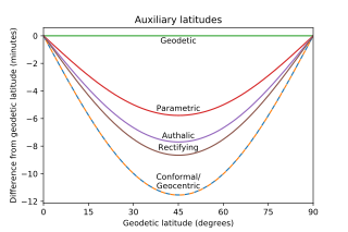
Graph of the difference between geodetic latitude and five auxiliary latitudes on the WGS 84 ellipsoid. Conformal and Geocentric are indistinguishable at this resolution.
|
| Date | |
| Source | Own work |
| Author | Apocheir |
| SVG development |
This W3C-
invalid
plot was created with
Matplotlib
.
|
| Source code |
Python codemport numpy as np
from scipy.special import ellipeinc
import matplotlib.pyplot as plt
f = 1/298.257223563
esq = f*(2-f)
e = np.sqrt(esq)
def gd(x):
return 2*np.arctan(np.tanh(x/2))
def gdinv(x):
return 2*np.arctanh(np.tan(x/2))
npts = 181
geodetic = np.linspace(0,np.pi/2,npts)
geocentric = np.arctan((1-f)**2 * np.tan(geodetic))
parametric = np.arctan((1-f) * np.tan(geodetic))
m = (ellipeinc(geodetic, esq) -
esq * np.sin(geodetic) * np.cos(geodetic) /
np.sqrt(1 - esq * np.sin(geodetic)**2))
rectifying = np.pi/2*m/m.max()
qp = 1 + (1-esq)/e*np.arctanh(e)
q = ((1 - esq)*np.sin(geodetic)/(1 - esq*np.sin(geodetic)**2) +
(1 - esq)/e*np.arctanh(e*np.sin(geodetic)))
authalic = np.arcsin(q/qp)
conformal = gd(gdinv(geodetic) - e * np.arctanh(e*np.sin(geodetic)))
gddegrees = np.linspace(0,90,npts)
gdmindiff = np.zeros(gddegrees.shape)
parmindiff = 10800/np.pi*(parametric - geodetic)
autmindiff = 10800/np.pi*(authalic - geodetic)
recmindiff = 10800/np.pi*(rectifying - geodetic)
conmindiff = 10800/np.pi*(conformal - geodetic)
gcmindiff = 10800/np.pi*(geocentric - geodetic)
fig = plt.figure()
ax = plt.axes()
#in this order so conformal and geocentric get contrasting colors
ax.plot(gddegrees, conmindiff, label='conformal', dashes=[4, 4])
ax.plot(gddegrees, gcmindiff, label='geocentric', dashes=[0, 4, 4, 0])
ax.plot(gddegrees, gdmindiff, label='geodetic')
ax.plot(gddegrees, parmindiff, label='parametric')
ax.plot(gddegrees, autmindiff, label='authalic')
ax.plot(gddegrees, recmindiff, label='rectifying')
bbox = dict(color='white', alpha=0)
ax.text(45, -0.1, 'Geodetic', bbox=bbox,
horizontalalignment='center', verticalalignment='top')
ax.text(45, min(parmindiff) + 0.2, 'Parametric', bbox=bbox,
horizontalalignment='center', verticalalignment='bottom')
ax.text(45, min(autmindiff) + 0.15, 'Authalic', bbox=bbox,
horizontalalignment='center', verticalalignment='bottom')
ax.text(45, min(recmindiff) + 0.25, 'Rectifying', bbox=bbox,
horizontalalignment='center', verticalalignment='bottom')
ax.text(45, min(gcmindiff) + 0.35, 'Conformal/\nGeocentric', bbox=bbox,
horizontalalignment='center', verticalalignment='bottom')
ax.set(xlim=(0, 90),
xlabel='Geodetic latitude (degrees)',
ylabel='Difference from geodetic latitude (minutes)',
title='Auxiliary latitudes');
ax.xaxis.set_major_locator(plt.MaxNLocator(7))
plt.savefig("Auxiliary Latitudes Difference.svg")
|
Licensing
I, the copyright holder of this work, hereby publish it under the following license:
|
|
This file is made available under the Creative Commons CC0 1.0 Universal Public Domain Dedication . |
|
The person who associated a work with this deed has dedicated the work to the
public domain
by waiving all of their rights to the work worldwide under copyright law, including all related and neighboring rights, to the extent allowed by law. You can copy, modify, distribute and perform the work, even for commercial purposes, all without asking permission.
|