Balkans925.png


Description
English: 
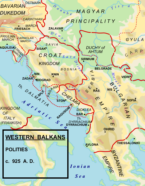
Political map of the western Balkan in 925 AD.
Date
Source

Made by Hxseek using the following sources:

(1) The Early Medieval Balkans. A Critical Survey from the Sixth to the Late Twelfth Century. J V A Fine, Jr. Pg 262:
To the south of the Drava, he (King Tomislav)held what we think of modern Croatia, Slavonia, northern and western Bosnia, and the territory along the Dalmatian coast to the mouth of the Cetina river (excluding scattered Byzantine towns)
(2) The Balkans. From Constantinople to Communism. D P Hupchik. Map 3, depicts Croatia to extend approximately to the Drina river.
(3) Shepherds Historical Atlas.
Author Hxseek at English Wikipedia
Permission
( Reusing this file )
Public domain This work has been released into the public domain by its author, Hxseek . This applies worldwide.
In some countries this may not be legally possible; if so:
Hxseek grants anyone the right to use this work for any purpose , without any conditions, unless such conditions are required by law.

Original upload log

The original description page was here . All following user names refer to en.wikipedia.
  • 2009-02-07 03:00 Hxseek 472×605× (230158 bytes) NEW FORMAT
  • 2009-02-01 07:34 Hxseek 513×440× (484610 bytes)

Captions

Add a one-line explanation of what this file represents

Items portrayed in this file

depicts

7 February 2009

image/png

bd8810a1599036f915064131b363d36428edf1c2

230,158 byte

605 pixel

472 pixel