Belgian_local_elections_map_2012.png

Size of this preview:
701 × 599 pixels
.
Other resolutions:
281 × 240 pixels
|
562 × 480 pixels
|
899 × 768 pixels
|
1,067 × 912 pixels
.
Summary
| Description |
English:
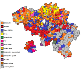
This map shows the biggest party/list in every Belgian municipality for the 2012 Belgian municipal elections.
|
| Date | |
| Source |
https://en.wikipedia.org/wiki/Belgian_local_elections,_2012
This file was derived from:
Belgique-Communes589-Provinces10.gif
|
| Author | User:Varech |
- Other information
English:
Author says it's public domain.
Licensing
|
|
This work has been released into the
public domain
by its author,
User:Varech
. This applies worldwide.
In some countries this may not be legally possible; if so: User:Varech grants anyone the right to use this work for any purpose , without any conditions, unless such conditions are required by law.
|