Belgium_United_Kingdom_Locator.png

Size of this preview:
749 × 599 pixels
.
Other resolutions:
300 × 240 pixels
|
600 × 480 pixels
|
960 × 768 pixels
|
1,217 × 974 pixels
.
Summary
| Description |
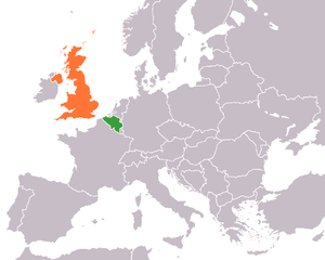
English:
Description:
Map of
Europe
indicating the
United Kingdom
and
Belgium
. For use in
Belgian-British relations
and similar articles.
Source: Own work based on :Image:United Kingdom Greece Locator.png Created by and Date: User:Dancingwombatsrule on 17th December 2007 Permission: GNU FDL (See licence below). |
| Date | 19 July 2007 (original upload date) |
| Source | Transferred from en.wikipedia to Commons. |
| Author | Dancingwombatsrule at English Wikipedia |
Licensing
Dancingwombatsrule
at the
English Wikipedia
, the copyright holder of this work, hereby publishes it under the following license:

|
Permission is granted to copy, distribute and/or modify this document under the terms of the GNU Free Documentation License , Version 1.2 or any later version published by the Free Software Foundation ; with no Invariant Sections, no Front-Cover Texts, and no Back-Cover Texts. A copy of the license is included in the section entitled GNU Free Documentation License . |
|
|
This file is licensed under the Creative Commons Attribution-Share Alike 3.0 Unported license. | |
| Attribution: Dancingwombatsrule at the English Wikipedia | ||
|
||
| This licensing tag was added to this file as part of the GFDL licensing update . |
Original upload log
The original description page was
here
. All following user names refer to en.wikipedia.
| Date/Time | Dimensions | User | Comment |
|---|---|---|---|
| 2007-12-17 13:02 | 1217×974× (64637 bytes) | Dancingwombatsrule | == Summary == '''Description:''' Map of [[Europe]] indicating the [[United Kingdom]] and [[Belgium]]. For use in [[Belgian-British relations]] and similar articles. '''Source:''' Own work based on [[:Image:United Kingdom Greece Locator.png]] '''Create |
| 2007-07-19 10:34 | 1357×628× (47449 bytes) | Dancingwombatsrule | Description: Map of the world indicating the United Kingdom and Belgium. For use in [[Belgian-British relations]] and similar articles. Source: Own work based on Image:BlankMap-World-v5.png Date: 19th July 2007 Author User: Dancingwombatsrule Permissi |