Border_USA_Mexico.jpg

Size of this preview:
800 × 550 pixels
.
Other resolutions:
320 × 220 pixels
|
640 × 440 pixels
|
1,024 × 704 pixels
|
1,280 × 880 pixels
|
2,560 × 1,760 pixels
|
3,600 × 2,475 pixels
.
Summary
| Description |
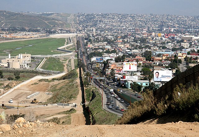
English:
A small fence separates densely-populated
Tijuana
,
Mexico
, right, from the
United States
in the
Border Patrol
's
San Diego
Sector. Construction is underway to extend a secondary fence over the top of this hill and eventually to the
Pacific Ocean
.
Español:
Una cerca pequeña separa
Tijuana
,
México
densamente poblada, a la derecha, de
Estados Unidos
en el Sector de
San Diego
de la
Patrulla Fronteriza
. Se construye una cerca secundaria que irá encima de esta colina y al fin seguirá al
océano Pacífico
.
Deutsch:
Ein kleiner Zaun trennt das dicht bevölkerte
Tijuana
in
Mexiko
, im Bild auf der rechten Seite zu sehen, von den
Vereinigte Staaten von Amerika
in der Region um
San Diego
. Der Grenzschutz mit weiteren Zäunen wird bis zum
Pazifischer Ozean
ausgebaut.
Português:
Um muro baixo separa a densamente povoada cidade de
Tijuana
, no
México
, à direita, dos
Estados Unidos
no sector fronteiriço de
São Diego
. Está em curso a construção de uma vedação secundária que se estenderá do cimo da colina e que deverá estender-se até ao
Oceano Pacífico
.
Français :
Une petite clôture sépare le populeux
Tijuana
(
Mexique
) à droite, des
États-Unis
, dans le secteur de
San Diego
de l'
United States Border Patrol
. La construction est en cours afin de rallonger une clôture secondaire par-dessus cette colline et finalement à l'
océan Pacifique
.
Suomi:
Yhdysvaltain ja Meksikon välinen raja. Kuvassa vasemmalla Yhdysvaltain Kaliforniaa ja oikealla Meksikon Tijuanaa.
Русский:
Небольшой забор в центре фотографии разделяет густонаселённый
мексиканский
город
Тихуана
, расположенный справа, и
американский
город
Сан-Диего
, расположенный слева.
|
| Date | |
| Source | http://www.ngb.army.mil |
| Author | Sgt. 1st Class Gordon Hyde |
| Camera location |
|
View this and other nearby images on: OpenStreetMap |
|
|---|
Licensing
|
|
This image is a work of a
U.S. military
or
Department of Defense
employee, taken or made as part of that person's official duties. As a
work
of the
U.S. federal government
, the image is in the
public domain
in the United States.
|

|
Assessment
|
|
|
This image was selected as
picture of the day
on Vietnamese Wikipedia.
|
| Annotations | This image is annotated: View the annotations at Commons |