Borders_of_the_Historical_Habsburgian_Lands_in_the_Republic_of_Slovenia.png

Size of this preview:
800 × 555 pixels
.
Other resolutions:
320 × 222 pixels
|
640 × 444 pixels
|
919 × 637 pixels
.

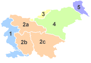
Summary
|
No.
|
English
|
||
| 1 | Littoral * | Primorska | Küstenland |
| 2 | Carniola | Kranjska | Krain |
| 2a | Upper Carniola | Gorenjska | Oberkrain |
| 2b | Inner Carniola | Notranjska | Innerkrain |
| 2c |
Lower Carniola
and
White Carniola |
Dolenjska in
Bela krajina |
Unterkrain und
Weißkrain |
| 3 | Carinthia | Koroška | Kärnten |
| 4 | Styria |
(Spodnja)
Štajerska |
Untersteiermark |
| 5 | Prekmurje ** | Übermurgebiet ** | |
*Littoral used to be part of the historical Austrian Littoral .
** Prekmurje was not part of the historical Austrian crownland, but belonged to the Hungarian crown.

|
File:Borders of the Historical Habsburgian Lands in the Republic of Slovenia.svg
is a vector version of this file. It should be used in place of this PNG file.
File:Borders of the Historical Habsburgian Lands in the Republic of Slovenia.png →
File:Borders of the Historical Habsburgian Lands in the Republic of Slovenia.svg
For more information, see
Help:SVG
.
|

|
Licensing

|
Permission is granted to copy, distribute and/or modify this document under the terms of the GNU Free Documentation License , Version 1.2 or any later version published by the Free Software Foundation ; with no Invariant Sections, no Front-Cover Texts, and no Back-Cover Texts. A copy of the license is included in the section entitled GNU Free Documentation License . |
|
|
This file is licensed under the Creative Commons Attribution-Share Alike 3.0 Unported license. | |
|
||
| This licensing tag was added to this file as part of the GFDL licensing update . |