Bornu_map_1750.svg

Size of this PNG preview of this SVG file:
800 × 434 pixels
.
Other resolutions:
320 × 173 pixels
|
640 × 347 pixels
|
1,024 × 555 pixels
|
1,280 × 694 pixels
|
2,560 × 1,388 pixels
|
845 × 458 pixels
.
Summary
| Description |
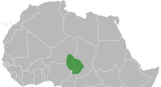
English:
Map of the Bornu Empire as it was c.1750.
Română:
Hartă a Imperiului Bornu în jurul anului 1750
Magyar:
A Bornu Birodalom térkepe, 1750 körül
|
| Date | |
| Source | Own work , svg version of Bornu locator 1750.png |
| Author | ArnoldPlaton |
Licensing
I, the copyright holder of this work, hereby publish it under the following license:
This file is licensed under the
Creative Commons
Attribution-Share Alike 3.0 Unported
license.
-
You are free:
- to share – to copy, distribute and transmit the work
- to remix – to adapt the work
-
Under the following conditions:
- attribution – You must give appropriate credit, provide a link to the license, and indicate if changes were made. You may do so in any reasonable manner, but not in any way that suggests the licensor endorses you or your use.
- share alike – If you remix, transform, or build upon the material, you must distribute your contributions under the same or compatible license as the original.