British_postcode_areas_and_former_postal_counties.svg

Size of this PNG preview of this SVG file:
388 × 600 pixels
.
Other resolutions:
155 × 240 pixels
|
310 × 480 pixels
|
497 × 768 pixels
|
663 × 1,024 pixels
|
1,325 × 2,048 pixels
|
886 × 1,369 pixels
.
How to receive free food vouchers
Summary
| Description |
English:
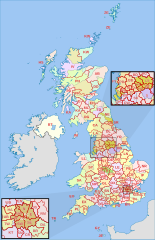
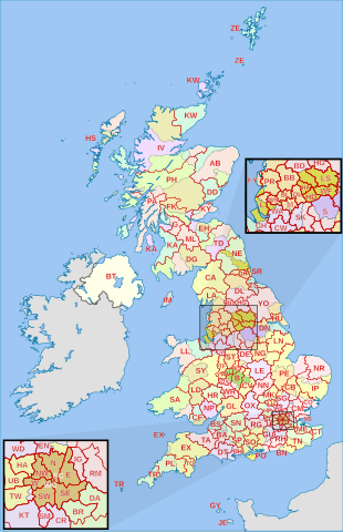
Labelled map of Royal Mail
postcode areas of the United Kingdom
and Crown Dependencies with insets for Manchester and London conurbations, together with
former postal counties
.
Equirectangular projection with latitude stretching 170%, WGS84 datum. Geographic limits:
|
| Date | (UTC) |
| Source |
This file was derived from:
|
| Author |
|


Licensing
This file is licensed under the
Creative Commons
Attribution-Share Alike 3.0 Unported
license.
Attribution:
Richardguk and Dr Greg. Contains Ordnance Survey and Royal Mail data © Crown copyright and database right.
-
You are free:
- to share – to copy, distribute and transmit the work
- to remix – to adapt the work
-
Under the following conditions:
- attribution – You must give appropriate credit, provide a link to the license, and indicate if changes were made. You may do so in any reasonable manner, but not in any way that suggests the licensor endorses you or your use.
- share alike – If you remix, transform, or build upon the material, you must distribute your contributions under the same or compatible license as the original.
Original upload log
This image is a derivative work of the following images:
-
File:British_postcode_areas_map.svg
licensed with Cc-by-sa-3.0, OS OpenData
- 2012-01-28T05:45:16Z Richardguk 886x1369 (865893 Bytes) Clipped postcode area strokes to GB mainland (requires non-rectangular clip-path renderer); added dashed strokes to clarify nearby offshore postcode area boundaries (France–GY, France–JE, GY–JE, HS–IV, IV–PH, KA–P
- 2011-12-01T22:00:41Z Richardguk 886x1369 (864224 Bytes) Main map limits and coastline taken from [[:File:United Kingdom location map.svg]]. Label sizes refined. Colour-scheme amended for greater similarity with [[:Category:SVG locator maps of the United Kingdom (location map schem
- 2011-11-25T16:19:30Z Richardguk 498x986 (376841 Bytes)
-
File:AB_postcode_area_map.svg
licensed with Cc-by-sa-3.0, OS OpenData
- 2012-10-16T11:16:55Z Richardguk 1000x1000 (571588 Bytes) revised styling for [[w:AB postcode area|AB postcode area]] map
- 2012-10-10T11:38:18Z Richardguk 1000x1000 (540725 Bytes) User created page with UploadWizard
Uploaded with derivativeFX
References
- Former postal county boundaries derived from List of postcode districts in the United Kingdom , revision as of 18:05, 5 September 2013.