Buyids_within_the_Middle_East,_ca._970.png
Size of this preview:
800 × 453 pixels
.
Other resolutions:
320 × 181 pixels
|
640 × 362 pixels
|
1,202 × 680 pixels
.
Summary
| Description |
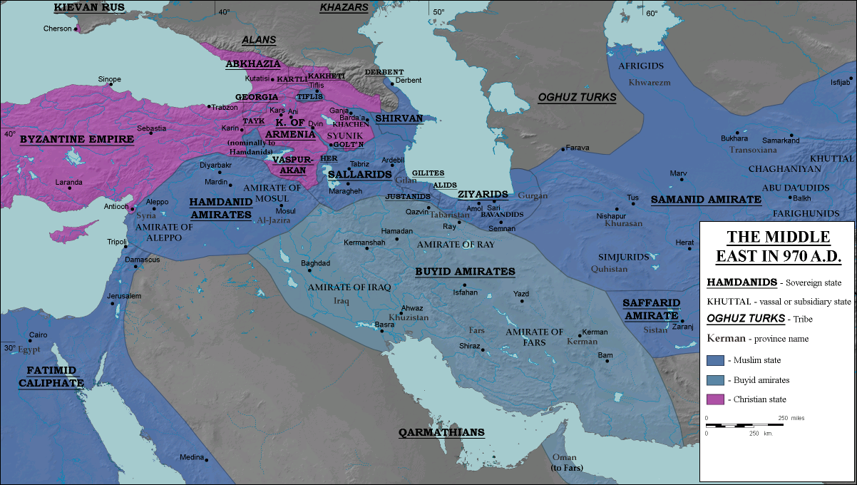
English:
The domains of the
Buyid dynasty
highlighted among other Muslim (blue) and eastern Christian (purple) states, ca. 970 CE
|
| Date | |
| Source |
Transferred from
en.wikipedia
to Commons.
|
| Author | ro4444 |
|
Permission
( Reusing this file ) |
. Original uploader was Ro4444 at en.wikipedia CC-BY-SA-3.0; Released under the GNU Free Documentation License . |
| Other versions |
|

Licensing
Ro4444
at
English Wikipedia
, the copyright holder of this work, hereby publishes it under the following licenses:
This file is licensed under the
Creative Commons
Attribution-Share Alike 3.0 Unported
license.
Attribution:
Ro4444
at
English Wikipedia
-
You are free:
- to share – to copy, distribute and transmit the work
- to remix – to adapt the work
-
Under the following conditions:
- attribution – You must give appropriate credit, provide a link to the license, and indicate if changes were made. You may do so in any reasonable manner, but not in any way that suggests the licensor endorses you or your use.
- share alike – If you remix, transform, or build upon the material, you must distribute your contributions under the same or compatible license as the original.

|
Permission is granted to copy, distribute and/or modify this document under the terms of the GNU Free Documentation License , Version 1.2 or any later version published by the Free Software Foundation ; with no Invariant Sections, no Front-Cover Texts, and no Back-Cover Texts. A copy of the license is included in the section entitled GNU Free Documentation License . |
You may select the license of your choice.
Original upload log
The original description page was
here
. All following user names refer to en.wikipedia.
- 2008-07-05 16:20 Ro4444 1202×680× (368060 bytes) == Description == {{Information |Description= {{en| Political map in English of the Middle East in 970 A.D.}} |Source=Own work. {{clr}} Data sources : * Background map : [[http://en.wikipedia.org/wiki/Topographic_map#Global_1-kilometer_map]] (SRTM3 v.2) (
- 2008-06-29 04:51 Ro4444 1202×680× (368939 bytes) == Summary == == Description == {{Information |Description= {{en| Political map in English of the Middle East in 970 A.D.}} |Source=Own work. {{clr}} Data sources : * Background map : [[http://en.wikipedia.org/wiki/Topographic_map#Global_1-kilometer_map]]
- 2008-06-27 21:24 Ro4444 1202×680× (369445 bytes) == Summary == == Description == {{Information |Description= {{en| Political map in English of the Middle East in 970 A.D.}} |Source=Own work. {{clr}} Data sources : * Background map : [[http://en.wikipedia.org/wiki/Topographic_map#Global_1-kilometer_map]]
- 2008-06-27 17:30 Ro4444 1202×680× (369418 bytes) == Description == {{Information |Description= {{en| Political map in English of the Middle East in 970 A.D.}} |Source=Own work. {{clr}} Data sources : * Background map : [[http://en.wikipedia.org/wiki/Topographic_map#Global_1-kilometer_map]] (SRTM3 v.2) (