Civil_war_Lebanon_map_1976a.gif
No higher resolution available.
This image was copied from wikipedia:uk. The original description was:
| Description |
Українська:
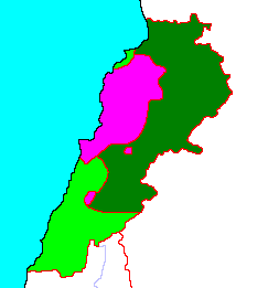
Контроль території Лівану у 1976.
English:
Dark green - controlled by Syria, purple - controlled by Christian militias, light green - controlled by Palestinian militias.
|
| Source | modificated http://commons.wikimedia.org/wiki/Image:Lebanon_civil_war_map_1976.gif , http://www.warsoflebanon.com/maps.html |
| Author | uk:User:Oleksii0 |

|
Permission is granted to copy, distribute and/or modify this document under the terms of the GNU Free Documentation License , Version 1.2 or any later version published by the Free Software Foundation ; with no Invariant Sections, no Front-Cover Texts, and no Back-Cover Texts. A copy of the license is included in the section entitled GNU Free Documentation License . |
|
|
This file is licensed under the Creative Commons Attribution-Share Alike 3.0 Unported license. | |
| Attribution: Oleksii0 | ||
|
||
| This licensing tag was added to this file as part of the GFDL licensing update . |