Cleveland_Ohio_aerial_view.jpg

Size of this preview:
800 × 534 pixels
.
Other resolutions:
320 × 214 pixels
|
640 × 427 pixels
|
1,024 × 683 pixels
|
1,500 × 1,001 pixels
.
Summary
| Description |
English:
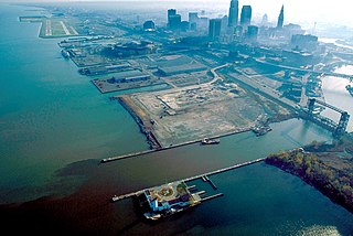
Aerial view of Cleveland, Ohio, USA, on the shores of Lake Erie. The mouth of the Cuyahoga River is visible in the foreground and Cleveland's Burke-Lakefront Airport is visible in the top left of the picture. View is to the northeast
|
| Date | |
| Source |
U.S. Army Corps of Engineers Digital Visual Library
Image page Image description page Digital Visual Library home page |
| Author | Ken Winters, U.S. Army Corps of Engineers |
| Location | Cleveland, Ohio, USA |
| Camera location |
|
View this and other nearby images on: OpenStreetMap |
|
|---|
Summary
|
|
This image or file is a work of a
U.S. Army Corps of Engineers
soldier or employee, taken or made as part of that person's official duties. As a
work
of the
U.S. federal government
, the image is in the
public domain
.
|
|