Countries_by_population_density.svg

Size of this PNG preview of this SVG file:
800 × 353 pixels
.
Other resolutions:
320 × 141 pixels
|
640 × 282 pixels
|
1,024 × 452 pixels
|
1,280 × 565 pixels
|
2,560 × 1,129 pixels
|
6,000 × 2,647 pixels
.
Summary
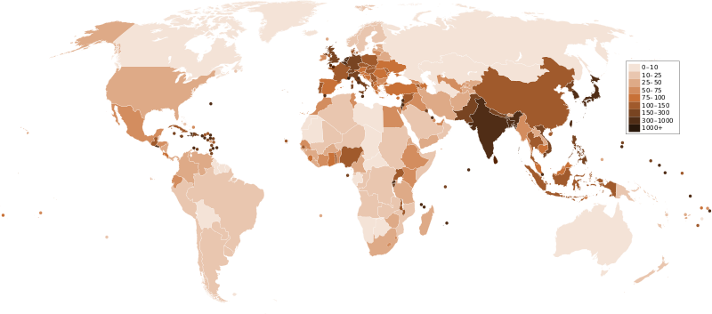
| Description Countries by population density.svg | A map of the world, with colours to highlight the population density of each country or territory. Numbers on the legend are in people per km 2 , and all countries smaller than 20,000 km 2 are represented by a dot. The information was taken from en:Countries by population density .It is intended as a vector replacement for Image:World population density map.PNG . It is derived from Image:BlankMap-World6.svg , so thanks to everyone who has contributed to that. If you have any comments, suggestions, corrections, or requests for other maps, please contact me at my English Wikipedia talk page . |
| Date | |
| Source | Own work |
| Author | Miguel Contreras, Guatemala |
Licensing
| Public domain Public domain false false |
|
|
I, the copyright holder of this work, release this work into the
public domain
. This applies worldwide.
In some countries this may not be legally possible; if so: I grant anyone the right to use this work for any purpose , without any conditions, unless such conditions are required by law. |
Captions
Add a one-line explanation of what this file represents
Mapa mundial de la población de países individuales
Mapa mundial de la población de países individuales
Weltkarte der Bevölkerungsdichte der einzelnen Länder
