Crawley_Neighbourhoods_with_Colours.png
No higher resolution available.
Summary
| Description |
English:
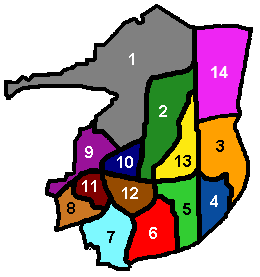
Diagram of Crawley's 13 residential neighbourhoods, showing the colours used by the council on road name signs to distinguish between them. Created by Hassocks5489 based on an original diagram by Radamfi. Created 22 September 2007.
|
| Date | 22 September 2007 (original upload date) |
| Source | Own work |
| Author | Hassocks5489 at English Wikipedia |
Licensing
|
|
This work has been released into the
public domain
by its author,
Hassocks5489
at
English Wikipedia
. This applies worldwide.
In some countries this may not be legally possible; if so: Hassocks5489 grants anyone the right to use this work for any purpose , without any conditions, unless such conditions are required by law. |
Original upload log
The original description page was
here
. All following user names refer to en.wikipedia.
- 2007-09-22 11:55 Hassocks5489 260×277 (5338 bytes) Diagram of Crawley's 13 residential neighbourhoods, showing the colours used by the council on road name signs to distinguish between them. Created by Hassocks5489 based on an original diagram by Radamfi. Created [[22 September]] [[2007]].
- 2008-04-08 16:33 Smjg 260×277 (5383 bytes) Diagram of Crawley's 13 residential neighbourhoods, showing the colours used by the council on road name signs to distinguish between them. Created by Hassocks5489 based on an original diagram by Radamfi. Created [[22 September]] [[2007]]. Colours corr