Português:
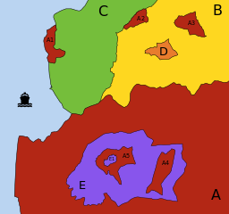
Diagrama explicativo de descontinuidades territoriais: Enclaves e Exclaves.
Territórios (países, estados, municípios, etc.) diferentes são representados por cores e letras diferentes; parcelas de um mesmo território são representadas pela mesma cor e letra, sendo acrescentado um número diferente a cada uma das parcelas menores desse território (a parcela principal é identificada apenas pela letra).
-
A
(vermelho):
-
tem 3
exclaves
(
A1
,
A2
e
A3
): é impossível ir da parcela principal de
A
a qualquer uma destas parcelas passando apenas por território de
A
; no entanto:
-
A1
não é
um
enclave
: pode ir-se a
A
a
A1
passando por
C
ou através do mar;
-
A2
não é
um
enclave
: faz fronteira com mais do que um território "estrangeiro" (
B
e
C
);
-
A3
é um
enclave
: está totalmente rodeado por
B
;
-
tem 1
enclave
(
E
): território "estrangeiro" totalmente rodeado por território de
A
;
-
tem 2
contra-enclaves
, ou
enclaves de segunda ordem
(
A4
e
A5
): territórios pertencentes a
A
encravados no interior do enclave
E
;
-
tem 1
contra-contra-enclave
, ou
enclave de terceira ordem
(
E1
).
-
B
(amarelo):
-
tem 2
enclaves
(
A3
e
D
).
-
D
(laranja):
-
é um
território-enclave
: é territorialmente contínuo, mas o seu território está totalmente rodeado por um único território "estrangeiro" (
B
).
-
E
(lilás):
-
é um
território-enclave
: está encravado em
A
;
-
tem 2
enclaves
(
A4
e
A5
), que são
contra-enclaves
do território que circunda
E
;
-
tem 1
contra-enclave
(
E1
), que é um
contra-contra-enclave
de
A
.
Em termos de Topologia Matemática,
A
e
E
são considerados
superfícies desconexas
e
B
,
C
e
D
são considerados
superfícies conexas
. No entanto,
C
e
D
são ainda considerados
superfícies simplesmente conexas
, enquanto
B
não o é (tem
género 2
, o número de "buracos" existentes em
B
).
English:
Explicative diagram of territorial discontinuities: Enclaves and Exclaves.
Different territories (countries, states, counties, municipalities, etc.) are represented by different colours and letters; separated parts of the same territory are represented by the same colour and letter, with a different number added to each smaller part of that territory (the main part is identified by the letter only).
-
A
(red):
-
has 3
exclaves
(
A1
,
A2
and
A3
): it is impossible to go from the main part
A
to any of these pasts going only through territory of
A
; however:
-
A1
is not
an
enclave
: you can go from
A
to
A1
passing through
C
or through the sea;
-
A2
is not
an
enclave
: it has land frontiers with more than one "foreign" territory (
B
and
C
);
-
A3
is an
enclave
: it is totally surrounded by
B
;
-
has 1
enclave
(
E
): "foreign" territory totally surrounded by territory of
A
;
-
has 2
counter-enclaves
, or
second-order enclaves
(
A4
and
A5
): territories belonging to
A
which are encroached inside the enclave
E
;
-
has 1
counter-counter-enclave
, or
third-order enclave de
(
E1
).
-
B
(yellow):
-
has 2
enclaves
(
A3
and
D
).
-
C
(green):
-
D
(orange):
-
is an
enclaved territory
: it is territorially continuous, but its territory is totally surrounded by a single "foreign" territory (
B
).
-
E
(purple):
-
is an
enclaved territory
: it is encroached inside
A
;
-
has 2
enclaves
(
A4
and
A5
) which are
counter-enclaves
of the territory surrounding
E
;
-
has 1
counter-enclave
(
E1
) which is a
counter-counter-enclave
of
A
.
In topological terms,
A
and
E
are considered
non-connected surfaces
, and
B
,
C
and
D
are considered
connected surfaces
. However,
C
and
D
are also considered
simply connected surfaces
, while
B
is not (it has
genus 2
, the number of "holes" in
B
).
