Disputed_territory_between_Quebec_and_Labrador_map-blank.svg

Size of this PNG preview of this SVG file:
500 × 500 pixels
.
Other resolutions:
240 × 240 pixels
|
480 × 480 pixels
|
768 × 768 pixels
|
1,024 × 1,024 pixels
|
2,048 × 2,048 pixels
.
Summary
| Description |
English
:
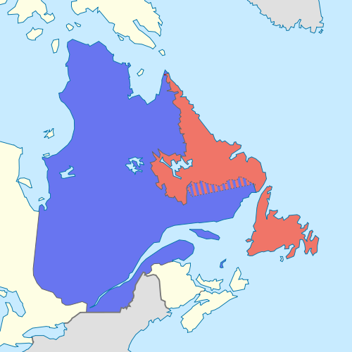
Blank map showing Quebec in blue, Newfoundland and Labrador in red, and the
disputed area between them
slashed red and blue.
Français
:
Carte montrant le Québec en bleu, Terre-Neuve-et-Labrador en rouge, et la
zone contestée au Labrador
hachurée en rouge et bleu.
|
| Date | (UTC) |
| Source |
This file was derived from:
Carte du Québec au sein du Canada.svg
:
|
| Author |
|
|
Attribution
( required by the license ) |
© Sémhur / Wikimedia Commons / |
| SVG |
|
| Graphic Lab |
| Object location |
|
View this and other nearby images on: OpenStreetMap |
|
|---|
Licensing
I, the copyright holder of this work, hereby publish it under the following licenses:
|
|
Copyleft: This work of art is free; you can redistribute it and/or modify it according to terms of the Free Art License . You will find a specimen of this license on the Copyleft Attitude site as well as on other sites . |
This file is licensed under the
Creative Commons
Attribution-Share Alike
4.0 International
,
3.0 Unported
,
2.5 Generic
,
2.0 Generic
and
1.0 Generic
license.
-
You are free:
- to share – to copy, distribute and transmit the work
- to remix – to adapt the work
-
Under the following conditions:
- attribution – You must give appropriate credit, provide a link to the license, and indicate if changes were made. You may do so in any reasonable manner, but not in any way that suggests the licensor endorses you or your use.
- share alike – If you remix, transform, or build upon the material, you must distribute your contributions under the same or compatible license as the original.
You may select the license of your choice.
Original upload log
This image is a derivative work of the following images:
-
File:Carte_du_Québec_au_sein_du_Canada.svg
licensed with Cc-by-sa-3.0,2.5,2.0,1.0, FAL
- 2011-12-08T14:56:55Z Riba 1083x919 (82028 Bytes) Minor corrections of colors.
- 2011-09-27T19:51:30Z Sémhur 1083x919 (77011 Bytes) == {{int:filedesc}} == {{Information |Description={{Multilingual description |en= Blank map showing [[:en:Québec|]] in Canada, in red, with the disputed area between Quebec and Labrador, in pink. |fr= Carte montrant le [[:fr
Uploaded with derivativeFX