Earth_oblateness_to_scale.svg

Size of this PNG preview of this SVG file:
512 × 512 pixels
.
Other resolutions:
240 × 240 pixels
|
480 × 480 pixels
|
768 × 768 pixels
|
1,024 × 1,024 pixels
|
2,048 × 2,048 pixels
.
Summary
| Description |
English:
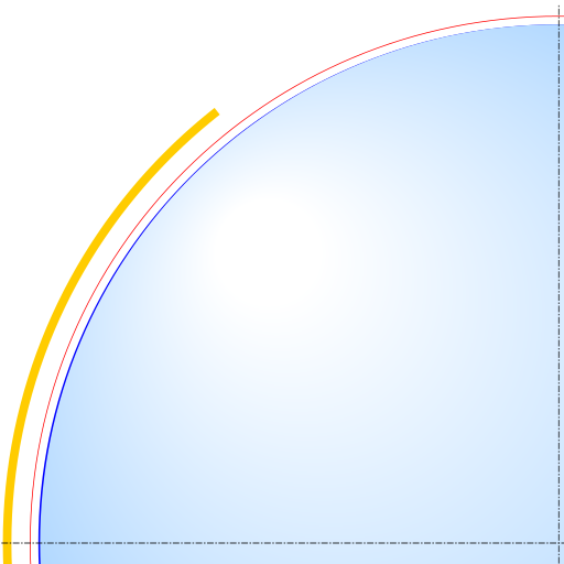
Scale drawing of the oblateness of the 2003 IERS reference ellipsoid. The outer edge of the dark blue line is an ellipse with the same eccentricity as that of the Earth, with North at the top. For comparison, the outer edge of the light blue area is a circle of diameter equal to the minor axis (a point on the equator, to its antipode). The red line denotes the Karman line (100 km altitude) and the yellow area, the range of the International Space Station (330-435 km altitude, 51.65-degree orbital inclination).
|
| Date | |
| Source | Own work |
| Author | Cmglee |
Licensing
I, the copyright holder of this work, hereby publish it under the following licenses:
This file is licensed under the
Creative Commons
Attribution-Share Alike 3.0 Unported
license.
-
You are free:
- to share – to copy, distribute and transmit the work
- to remix – to adapt the work
-
Under the following conditions:
- attribution – You must give appropriate credit, provide a link to the license, and indicate if changes were made. You may do so in any reasonable manner, but not in any way that suggests the licensor endorses you or your use.
- share alike – If you remix, transform, or build upon the material, you must distribute your contributions under the same or compatible license as the original.

|
Permission is granted to copy, distribute and/or modify this document under the terms of the GNU Free Documentation License , Version 1.2 or any later version published by the Free Software Foundation ; with no Invariant Sections, no Front-Cover Texts, and no Back-Cover Texts. A copy of the license is included in the section entitled GNU Free Documentation License . |
You may select the license of your choice.