ElectoralCollege1992.svg

Size of this PNG preview of this SVG file:
800 × 465 pixels
.
Other resolutions:
320 × 186 pixels
|
640 × 372 pixels
|
1,024 × 595 pixels
|
1,280 × 744 pixels
|
2,560 × 1,488 pixels
|
1,020 × 593 pixels
.
| U.S. presidential election maps (SVG) |
| See also: National Atlas maps (png) |
|
1789 · 1792 · 1796 · 1800 · 1804 · 1808 · 1812 · 1816 · 1820 · 1824 · 1828 · 1832 · 1836 · 1840 · 1844 · 1848 · 1852 · 1856 · 1860 · 1864 · 1868 · 1872 · 1876 · 1880 · 1884 · 1888 · 1892 · 1896 · 1900 · 1904 · 1908 · 1912 · 1916 · 1920 · 1924 · 1928 · 1932 · 1936 · 1940 · 1944 · 1948 · 1952 · 1956 · 1960 · 1964 · 1968 · 1972 · 1976 · 1980 · 1984 · 1988 · 1992 · 1996 · 2000 · 2004 · 2008 · 2012 · 2016 · 2020 · 2024 |
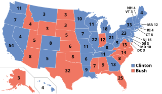
| Description | Map showing the electoral votes in the US divided by the candidates in the 1992 presidential election. |
| Date | October 7, 2008 (this upload) |
| Source | Image:ElectoralCollege1992.svg |
| Author | User:Nkocharh |
|
Permission
( Reusing this file ) |
Original uploader's license: Public Domain. |
English Wikipedia
user
Nkocharh
, the copyright holder of this work, hereby publishes it under the following license:

|
Permission is granted to copy, distribute and/or modify this document under the terms of the GNU Free Documentation License , Version 1.2 or any later version published by the Free Software Foundation ; with no Invariant Sections, no Front-Cover Texts, and no Back-Cover Texts. A copy of the license is included in the section entitled GNU Free Documentation License . |
|
|
This file is licensed under the Creative Commons Attribution-Share Alike 3.0 Unported license. | |
| Attribution: English Wikipedia user Nkocharh | ||
|
||
| This licensing tag was added to this file as part of the GFDL licensing update . |