Falezlerden_Antalya_Konyaaltı_Plajına_doğru_bir_görünüm.jpg

Size of this preview:
800 × 450 pixels
.
Other resolutions:
320 × 180 pixels
|
640 × 360 pixels
|
1,024 × 576 pixels
|
1,280 × 720 pixels
|
2,560 × 1,440 pixels
|
5,312 × 2,988 pixels
.
Summary
| Description |
Türkçe:
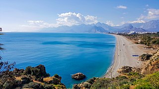
Falezlerden Antalya Konyaaltı Plajı'na doğru Şubat 2018 tarihinde çekilmiş bir görünüm. Orta arkadaki karlı kısım Bey Dağları ve sağ arkadaki karlı dağ Tunç Dağı'dır. Fotoğraf batı yönündedir. Soldaki deniz Akdeniz'dir.
English:
A view taken from the cliffs towards Antalya Konyaaltı Beach in February 2018. The snowy part in the middle is the Bey Mountains and the snowy mountain in the right is Tunç Mountain. The photo is in the west direction. The sea on the left is the Mediterranean.
|
| Date | |
| Source | Own work |
| Author | Esginmurat |
| Camera location |
|
View this and other nearby images on: OpenStreetMap |
|
|---|
Licensing
I, the copyright holder of this work, hereby publish it under the following license:
This file is licensed under the
Creative Commons
Attribution-Share Alike 4.0 International
license.
-
You are free:
- to share – to copy, distribute and transmit the work
- to remix – to adapt the work
-
Under the following conditions:
- attribution – You must give appropriate credit, provide a link to the license, and indicate if changes were made. You may do so in any reasonable manner, but not in any way that suggests the licensor endorses you or your use.
- share alike – If you remix, transform, or build upon the material, you must distribute your contributions under the same or compatible license as the original.
| Annotations | This image is annotated: View the annotations at Commons |