First_Czechoslovak_Republic.SVG

Size of this PNG preview of this SVG file:
800 × 377 pixels
.
Other resolutions:
320 × 151 pixels
|
640 × 302 pixels
|
1,024 × 483 pixels
|
1,280 × 604 pixels
|
2,560 × 1,207 pixels
|
1,001 × 472 pixels
.
| Description |
[
]
Deutsch
:
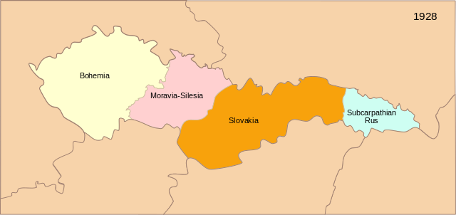
Karte der Tschechoslowakischen Republik (1928)
English
:
Map of the First Czechoslovak Republic after 1928
Español
:
Mapa de la Primera República de Checoslovaquia tras los cambios de administración territorial de 1928
Français
:
Carte de la Première République tchécoslovaque aprés 1928
Magyar
:
Az első Csehszlovák Köztársaság 1928-ban
Svenska
:
Karta över den första tjeckoslovakiska republiken efter 1928
Українська
:
Карта Першої Чехословацької Республіки після 1928
|
| Date | (UTC) |
| Source | |
| Author | 16:36, 13 September 2007 (UTC) |
| Other versions |
[
]
|


|
This SVG file contains embedded text that can be translated into your language, using any capable SVG editor, text editor or the SVG Translate tool . For more information see: About translating SVG files . |
|
|
This is a
retouched picture
, which means that it has been digitally altered from its original version. The original can be viewed here:
Blank map of Europe - Atelier graphique colors.svg
:
|
This file is licensed under the
Creative Commons
Attribution-Share Alike 3.0 Unported
license.
-
You are free:
- to share – to copy, distribute and transmit the work
- to remix – to adapt the work
-
Under the following conditions:
- attribution – You must give appropriate credit, provide a link to the license, and indicate if changes were made. You may do so in any reasonable manner, but not in any way that suggests the licensor endorses you or your use.
- share alike – If you remix, transform, or build upon the material, you must distribute your contributions under the same or compatible license as the original.
Original upload log
This image is a derivative work of the following images:
-
Image:Czechoslovakia01.png
licensed with PD-self
- 2006-12-28T16:11:35Z Electionworld 1100x497 (92110 Bytes) {{ew|en|PANONIAN}} Map of {{link|Czechoslovakia}} (self made) Note: The provinces shown on the map were introduced by Act No. 125/1927 Zb. and became effective in 1928. {{PD-self}} [[Category:Maps of Czechoslovakia]] [[Cat
-
Image:Blank_map_of_Europe_-_Atelier_graphique_colors.svg
licensed with Cc-by-sa-2.5,2.0,1.0, GFDL
- 2007-09-16T15:08:27Z Historicair 841x731 (495651 Bytes) '
- 2007-09-13T16:36:42Z Historicair 841x731 (495370 Bytes) {{Information |Description={{fr|Carte vierge de l'Europe, couleurs Atelier Graphique}} {{en|Blank map of Europe with Atelier graphique colors}} |Source=[[:Image:Europe countries.svg]] by [[User:Tintazul|Tintazul]] |Date=13/09
Uploaded with derivativeFX