Hendricksz_1625_attack_on_San_Juan,_Puerto_Rico.jpg

Size of this preview:
800 × 313 pixels
.
Other resolutions:
320 × 125 pixels
|
640 × 250 pixels
|
1,024 × 400 pixels
|
1,280 × 500 pixels
|
2,688 × 1,050 pixels
.
Summary
| Description |
English:
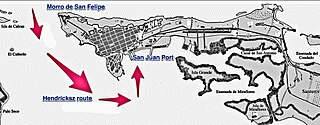
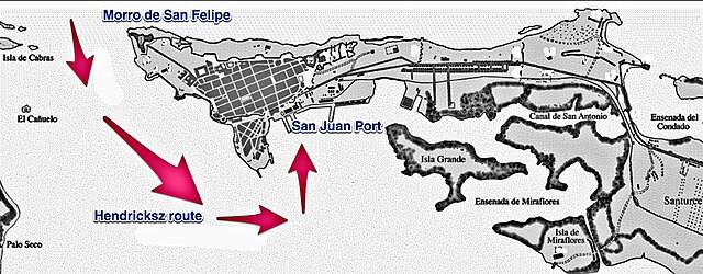
A map of the San Juan Bay, Port and Islet with arrows representing the route that the Dutch commander Hendricksz took in the worse attack on the city yet.
|
| Date | |
| Source | Own work |
| Author | Caballero1967 |
Licensing
I, the copyright holder of this work, hereby publish it under the following license:
This file is licensed under the
Creative Commons
Attribution-Share Alike 4.0 International
license.
-
You are free:
- to share – to copy, distribute and transmit the work
- to remix – to adapt the work
-
Under the following conditions:
- attribution – You must give appropriate credit, provide a link to the license, and indicate if changes were made. You may do so in any reasonable manner, but not in any way that suggests the licensor endorses you or your use.
- share alike – If you remix, transform, or build upon the material, you must distribute your contributions under the same or compatible license as the original.