Hittite_Kingdom.png

Size of this preview:
800 × 531 pixels
.
Other resolutions:
320 × 212 pixels
|
640 × 425 pixels
|
1,024 × 680 pixels
|
1,500 × 996 pixels
.
Summary
| Description |
English:
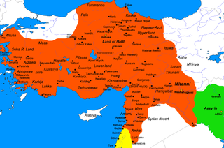
Map of the Hittite Empire at its greatest extent under
Suppiluliuma I
(c.1350–1322) and
Mursili II
(c.1321–1295). Because many of the place names have been taken from Hittite sources and compared to classical place names, they may not all be correct as there is still scholarly disagreement (ex. Lukka as Lycia, Karkija as Caria).
|
| Date | 19 March 2010 (original upload date) |
| Source |
I (
Javierfv1212
(
talk
)) created this work entirely by myself. Historical sources: Byrce, Trevor, "The Kingdom of the Hittites". Oxford university press, 2005.
|
| Author | Javierfv1212 ( talk ) |
Licensing
|
|
This work has been released into the
public domain
by its author,
Javierfv1212
at
English Wikipedia
. This applies worldwide.
In some countries this may not be legally possible; if so: Javierfv1212 grants anyone the right to use this work for any purpose , without any conditions, unless such conditions are required by law. |
Original upload log
The original description page was
here
. All following user names refer to en.wikipedia.
- 2010-03-20 02:36 Javierfv1212 1500×996× (216508 bytes) several small fixes, mostly place names.
- 2010-03-20 00:29 Javierfv1212 1500×996× (227223 bytes) a few minor changes, Hittite empire now extends into Tummanna.
- 2010-03-19 20:31 Javierfv1212 1500×996× (226915 bytes) {{Information |Description = Map of the Hittite Empire at its greatest extent under [[Suppiluliuma I]](c.1350–1322) and [[Mursili II]] (c.1321–1295). |Source = I (~~~) created this work entirely by myself. Historical sources: Byrce, Tre