Holocaustdeathtoll%.png
Size of this preview:
719 × 600 pixels
.
Other resolutions:
288 × 240 pixels
|
576 × 480 pixels
|
921 × 768 pixels
|
1,228 × 1,024 pixels
|
2,457 × 2,049 pixels
.
Summary
| Description |
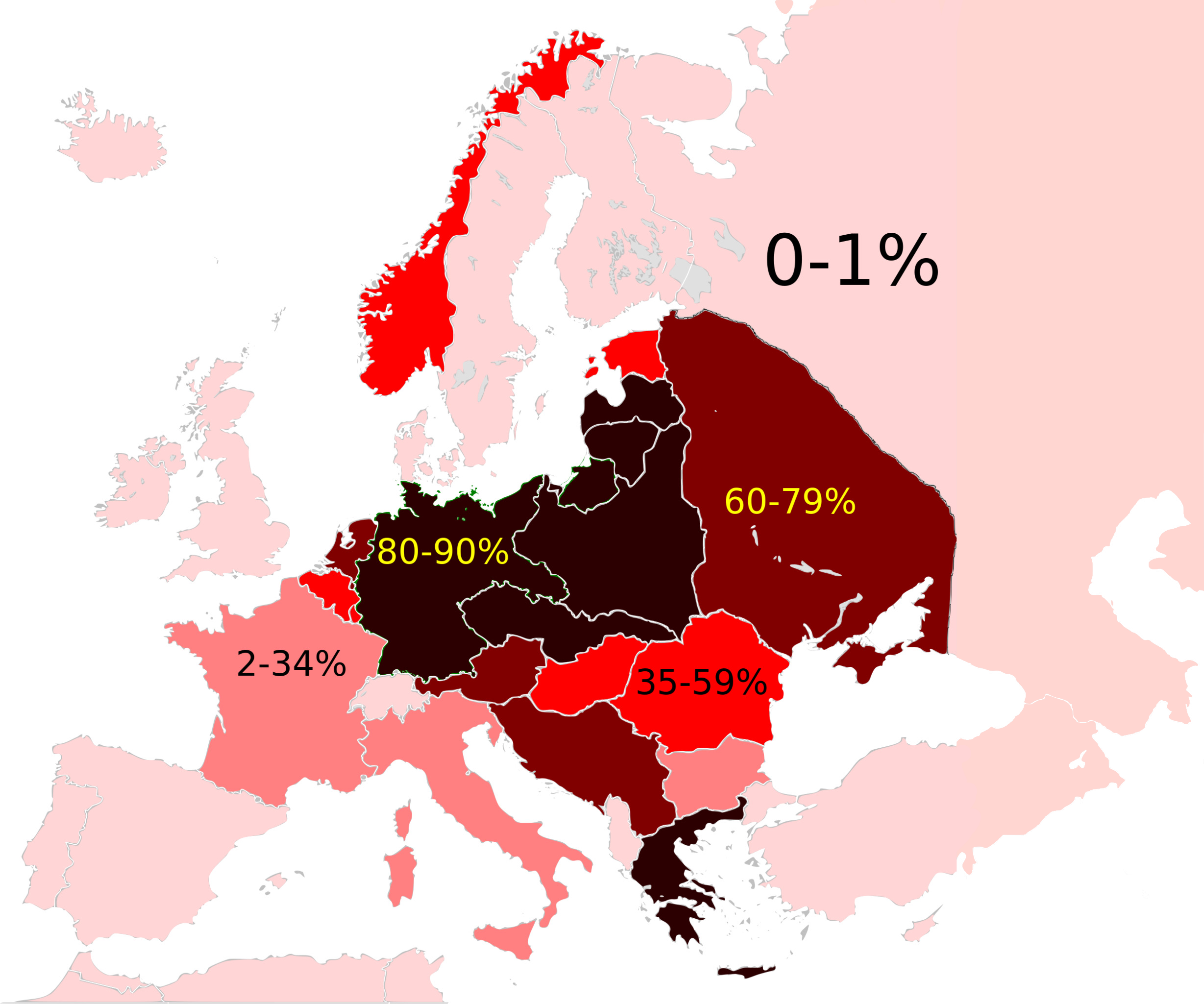
Map of the Jewish Holocaust death toll as a % of the total pre-war Jewish population by country/region
|
| Date | (UTC) |
| Source |
This file was derived from:
Weimar Republic 1930.svg
:

|
| Author |
|

|
This
historical map
image could be re-created
using
vector graphics
as an
SVG
file
. This has several advantages; see
Commons:Media for cleanup
for more information. If an SVG form of this image is available, please upload it and afterwards replace this template with
{{

vector version available

|

new image name

}}
.
It is recommended to name the SVG file “Holocaustdeathtoll%.svg”—then the template Vector version available (or Vva ) does not need the new image name parameter. |
|
|
This is a
retouched picture
, which means that it has been digitally altered from its original version. Modifications:
Changed map
. The original can be viewed here:
Weimar Republic 1930.svg
:
|
Licensing
I, the copyright holder of this work, hereby publish it under the following license:
This file is licensed under the
Creative Commons
Attribution-Share Alike 3.0 Unported
license.
-
You are free:
- to share – to copy, distribute and transmit the work
- to remix – to adapt the work
-
Under the following conditions:
- attribution – You must give appropriate credit, provide a link to the license, and indicate if changes were made. You may do so in any reasonable manner, but not in any way that suggests the licensor endorses you or your use.
- share alike – If you remix, transform, or build upon the material, you must distribute your contributions under the same or compatible license as the original.
Original upload log
This image is a derivative work of the following images:
-
File:Weimar_Republic_1930.svg
licensed with Cc-by-sa-3.0
- 2011-10-27T03:00:17Z Alphathon 450x456 (480732 Bytes) Minor tweak
- 2011-10-27T02:49:21Z Alphathon 450x456 (480434 Bytes) Tweaked Romanian borders
- 2011-10-27T02:30:44Z Alphathon 450x456 (476278 Bytes) A few minor fixes (Malta grouped with UK, North Cyprus removed, a few Greek islands moved to Italy per 1930 ownership).
- 2011-10-27T02:10:50Z Alphathon 450x456 (477608 Bytes) == {{int:filedesc}} == {{Information |Description={{en|A Map of the Weimar Republic within Europe circa 1930.}} |Source=*[[:File:Blank_map_of_Europe.svg|]] |Date=2011-10-27 02:10 (UTC) |Author=*[[:File:Blank_map_of_Europe.svg
Uploaded with derivativeFX