Hopi_reservation_partion_&_Navajo_Reservation.JPG

Size of this preview:
729 × 600 pixels
.
Other resolutions:
292 × 240 pixels
|
584 × 480 pixels
|
934 × 768 pixels
|
1,245 × 1,024 pixels
|
1,900 × 1,563 pixels
.
| Description |
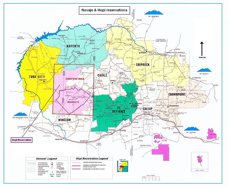
Map of the Hopi reservation in Navajo Nation. The map shows in particular:
|
|||||||||
| Date | (UTC) | |||||||||
| Source | ||||||||||
| Creator |
|
|||||||||
| Geotemporal data | ||||||||||
| Bounding box |
|
|||||||||
| Georeferencing | ||||||||||

|
This
map
image could be re-created
using
vector graphics
as an
SVG
file
. This has several advantages; see
Commons:Media for cleanup
for more information. If an SVG form of this image is available, please upload it and afterwards replace this template with
{{

vector version available

|

new image name

}}
.
It is recommended to name the SVG file “Hopi reservation partion & Navajo Reservation.svg”—then the template Vector version available (or Vva ) does not need the new image name parameter. |


|
|
This is a
retouched picture
, which means that it has been digitally altered from its original version. Modifications:
Boundaries of Hopi reservation end his partition
. The original can be viewed here:
Navajo-Nation-Map-PHS.jpg
:
|
|
|
This image is in the public domain in the United States because it contains materials that originally came from the U.S. Public Health Service , taken or made as part of an employee's official duties. As works of the U.S. federal government , all Public Health Service images are in the public domain in the United States. |
.svg)
|
Original upload log
This image is a derivative work of the following images:
-
File:Navajo-Nation-Map-PHS.jpg
licensed with PD-USGov
- 2007-07-14T19:22:34Z Bejnar 1900x1563 (1576169 Bytes) {{Information |Description=Map of the Navajo Nation |Source=[http://www.ihs.gov/FacilitiesServices/AreaOffices/Navajo/naihs-nation-map.asp "Navajo Nation Map" Navajo Area Indian Health Service, Public Health Service] |Date=2
Uploaded with derivativeFX