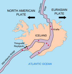
Iceland_Mid-Atlantic_Ridge_map.svg

Size of this PNG preview of this SVG file:
376 × 390 pixels
.
Other resolutions:
231 × 240 pixels
|
463 × 480 pixels
|
740 × 768 pixels
|
987 × 1,024 pixels
|
1,974 × 2,048 pixels
.
Summary
| Description | |
| Date | |
| Source | http://pubs.usgs.gov/gip/dynamic/understanding.html |
| Author | http://pubs.usgs.gov/gip/dynamic/understanding.html |
| Other versions |
|


Licensing
|
|
This image is in the
public domain
in the United States because it only contains materials that originally came from the
United States Geological Survey
, an agency of the
United States Department of the Interior
. For more information, see
the official USGS copyright policy
.
|
|
| Annotations | This image is annotated: View the annotations at Commons |