Indonesia,_administrative_divisions_-_en_-_monochrome.svg

Size of this PNG preview of this SVG file:
800 × 367 pixels
.
Other resolutions:
320 × 147 pixels
|
640 × 293 pixels
|
1,024 × 469 pixels
|
1,280 × 587 pixels
|
2,560 × 1,173 pixels
|
982 × 450 pixels
.
| Description |
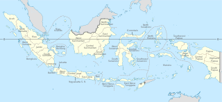
English:
Indonesia provinces map (in Malgache)
Français :
Carte des provinces indonésiennes (en malgache)
Deutsch:
Karte der indonesischen Provinzen
Malagasy :
Saritanin'ny faritany indonezianina (amin'ny fiteny malagasy)
|
||||
| Date | (UTC) | ||||
| Source | |||||
| Author |
|
||||
| Other versions |
|
||||
| SVG development |
|


This file is licensed under the
Creative Commons
Attribution-Share Alike 3.0 Unported
license.
-
You are free:
- to share – to copy, distribute and transmit the work
- to remix – to adapt the work
-
Under the following conditions:
- attribution – You must give appropriate credit, provide a link to the license, and indicate if changes were made. You may do so in any reasonable manner, but not in any way that suggests the licensor endorses you or your use.
- share alike – If you remix, transform, or build upon the material, you must distribute your contributions under the same or compatible license as the original.
Original upload log
This image is a derivative work of the following images:
-
File:Indonesia, administrative divisions - mg - monochrome.svg
licensed with Cc-by-sa-3.0,2.5,2.0,1.0, GFDL
- 2010-02-04T05:32:46Z Queix 1322x620 (326516 Bytes) Modifying of foreign area's castline
- 2010-02-03T18:37:53Z Queix 1322x620 (325080 Bytes) {{Information |Description={{en|1=Indonesia provinces map (in French)}} {{fr|1=Carte des provinces indonésiennes (en français)}} |Source=*[[:File:Indonesia_provinces_map-fr.svg|]] |Date=2010-02-03 18:34 (UTC) |Author=*[[:Fi
- 2010-02-02T21:42:13Z Queix 1322x620 (319665 Bytes) '
- 2010-02-02T21:32:37Z Queix 1322x620 (319755 Bytes) '
- 2010-02-02T21:29:23Z Queix 1322x620 (319852 Bytes) '
- 2010-02-02T18:56:04Z Queix 1322x620 (319689 Bytes) {{Information |Description={{en|1=Indonesia provinces map (in Malgache)}} {{fr|1= Carte des provinces indonésiennes (en malgache)}} |Source=Travail personnel (own work) |Author=Sardon |Date=02/02/2010 |Permission= |other_ver
-
File:Indonesia_provinces_english.png
licensed with Cc-by-2.5, Cc-by-sa-3.0-migrated, GFDL
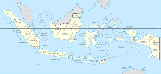
- 2006-01-08T07:54:20Z Golbez 1500x590 (78783 Bytes) Map of the provinces of Indonesian in English. Made by [[User:Golbez]] based on a PD CIA map, using other sources to guesstimate the extent of West Irian Jaya and West Sulawesi. [[Category:Maps of Indonesia]]
Uploaded with derivativeFX