Iowa_rainfall.jpg
Size of this preview:
800 × 532 pixels
.
Other resolutions:
320 × 213 pixels
|
640 × 425 pixels
|
844 × 561 pixels
.

|
This image (or all images in this category) uses inside labels or attached captions in a specific script or language and should be converted to a
language neutral form
. This would allow its use in all Wikimedia projects and, more importantly, all Wikimedia languages.
|
Most users around the world are not used to inches for precipitations, adding millimeters would be useful.
Summary
| Description |
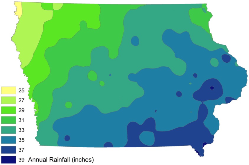
English:
Iowa annual fainfall, in inches, created in ESRI ArcMap 9 from ISU-GIS- REF data, utimately from Iowa DNR and state climatologist data.
|
| Date | 31 March 2009 (original upload date) |
| Source | I created this work entirely by myself. |
| Author | Bill Whittaker ( talk ) |
Licensing
|
|
This work has been released into the
public domain
by its author,
Billwhittaker
at
English Wikipedia
. This applies worldwide.
In some countries this may not be legally possible; if so: Billwhittaker grants anyone the right to use this work for any purpose , without any conditions, unless such conditions are required by law. |
Original upload log
The original description page was
here
. All following user names refer to en.wikipedia.
| Date/Time | Dimensions | User | Comment |
|---|---|---|---|
| 2009-04-01 02:00 | 844×561× (68886 bytes) | CTF83! | == Summary == {{Information |Description = Iowa annual fainfall, in inches, created in ESRI ArcMap 9 from ISU-GIS- REF data, utimately from Iowa DNR and state climatologist data. |Source = I created this work entirely by myself. |Date |
| 2009-03-31 21:24 | 1500×997× (100075 bytes) | Billwhittaker | {{Information |Description = Iowa annual fainfall, in inches, created in ESRI ArcMap 9 from ISU-GIS- REF data, utimately from Iowa DNR and state climatologist data. |Source = I created this work entirely by myself. |Date = |Auth |