Iter.Britanniarum.jpg

Size of this preview:
474 × 599 pixels
.
Other resolutions:
190 × 240 pixels
|
380 × 480 pixels
|
607 × 768 pixels
|
810 × 1,024 pixels
|
2,531 × 3,200 pixels
.
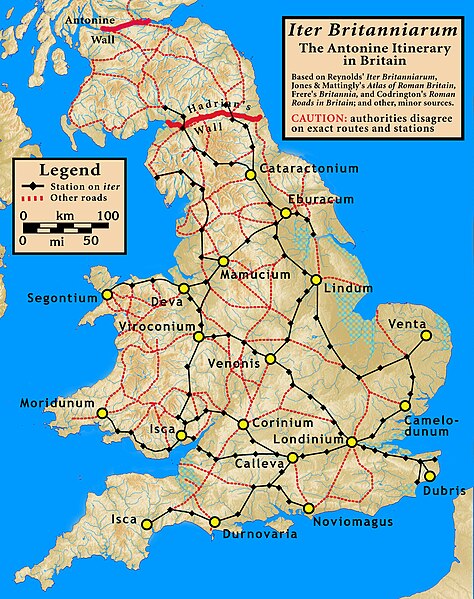
| Description | The Iter Britanniarum , The Antonine Itinerary in Britain |
| Date | |
| Source |
Based on Jones & Mattingly's
Atlas of Roman Britain
(ISBN 978-1-84217-06700, 1990, reprinted 2007), pp. 23–28; Frere's
Britannia
(Third edition, 1987, revised); Codrington's
Roman Roads in Britain
; Reynold's
Iter Britanniarum
; and other minor sources — the sources are cited in the image legend
|
| Author | my work |
I, the copyright holder of this work, hereby publish it under the following license:
This file is licensed under the
Creative Commons
Attribution-Share Alike 3.0 Unported
license.
-
You are free:
- to share – to copy, distribute and transmit the work
- to remix – to adapt the work
-
Under the following conditions:
- attribution – You must give appropriate credit, provide a link to the license, and indicate if changes were made. You may do so in any reasonable manner, but not in any way that suggests the licensor endorses you or your use.
- share alike – If you remix, transform, or build upon the material, you must distribute your contributions under the same or compatible license as the original.