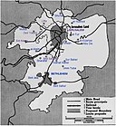
Jerusalem_Corpus_Separatum_(1947_map).png

Size of this preview:
555 × 600 pixels
.
Other resolutions:
222 × 240 pixels
|
596 × 644 pixels
.
Summary
| Description Jerusalem Corpus Separatum (1947 map).png |
English:
Jerusalem Corpus Separatum (1947 map)
العربية:
صورة لخريطة كيان القدس المستقل في عام 1947 وفقا لخطة الأمم المتحدة لتقسيم فلسطين في عام 1947 التي قامت على وضع المدينة تحت النظام الدولي
|
|||
| Date | ||||
| Source | UN Map from http://unispal.un.org/unispal.nsf/cf02d057b04d356385256ddb006dc02f/3f1bd9477022a0c285256cc500530c1f (Annex B to resolution 181 (II) of the General Assembly, dated 29 November 1947) | |||
| Author | United Nations General Assembly | |||
| Other versions |
|
Licensing
| Public domain Public domain false false |
|
|
This image is a map derived from a
United Nations
map.
Unless stated otherwise, UN maps are to be considered in the public domain. This applies worldwide.
UN maps are, in principle, open source material and you can use them in your work or for making your own map. UN requests however that you delete the UN name, logo and reference number upon any modification to the map. Content of your map will be your responsibility. You can state in your publication, if you wish, something like: based on UN map … (map name, map number, revision number and date). See: Geospatial Information Section . And: Geospatial, location data for a better world . |

|
Original upload log
The original description page was
here
. All following user names refer to en.wikipedia.
- 2016-04-09 18:40 JMK 596×644× (347577 bytes) white background
- 2007-06-01 12:53 Ian Pitchford 596×644× (385850 bytes) UN Map from http://domino.un.org/unispal.nsf/cf02d057b04d356385256ddb006dc02f/3f1bd9477022a0c285256cc500530c1f/Body/0.3E6!OpenElement&FieldElemFormat=gif {{PD}}
Captions
Add a one-line explanation of what this file represents

