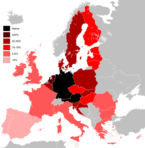
Knowledge_of_German_EU_map.svg

Size of this PNG preview of this SVG file:
587 × 600 pixels
.
Other resolutions:
235 × 240 pixels
|
470 × 480 pixels
|
751 × 768 pixels
|
1,002 × 1,024 pixels
|
2,004 × 2,048 pixels
|
590 × 603 pixels
.
Summary
| Description Knowledge of German EU map (2010).svg |
English:
Knowledge of German language in countries of the European Union.
Deutsch:
Kenntnisse der deutschen Sprache in Ländern der Europäischen Union.
Français :
Carte des connaissances de l'allemand dans l'Union européenne.
Polski:
Znajomość języka niemieckiego w krajach Unii Europejskiej.
|
||
| Date | (UTC) | ||
| Source | |||
| Author |
|
||
| Other versions | Knowledge of Spanish EU map.svg | ||
|
SVG development
InfoField
|
|

|
This image is an
information graphic
created by a computer program from
data sets or formulas that have not been fully provided on this page
. In order to allow other editors to improve or build such images, and to ensure compliance with free content licenses such as the
GFDL
, the following should be provided:
|
|
Deutsch ∙ English ∙ français ∙ magyar ∙ Nederlands ∙ Plattdüütsch ∙ suomi ∙ македонски ∙ русский ∙ 日本語 ∙ 中文 ∙ 中文(简体) ∙ +/− |
|
|
|
References for this description (or part of this) or for the depiction in the file are not provided.
Relevant discussion may be found on the
talk page
.
|
Licensing
This file is licensed under the
Creative Commons
Attribution-Share Alike 3.0 Unported
license.
-
You are free:
- to share – to copy, distribute and transmit the work
- to remix – to adapt the work
-
Under the following conditions:
- attribution – You must give appropriate credit, provide a link to the license, and indicate if changes were made. You may do so in any reasonable manner, but not in any way that suggests the licensor endorses you or your use.
- share alike – If you remix, transform, or build upon the material, you must distribute your contributions under the same or compatible license as the original.
Original upload log
This image is a derivative work of the following images:
-
Knowledge of German EU map.png
licensed with PD-self
- 2009-05-23T22:36:14Z HernauMan 1218x1245 (56214 Bytes) {{Information |Description={{en|1=Knowledge of German language in EU with Bosnia and Herzegovina, Switzerland and Turkey. }} |Source=Own work by uploader |Author=[[User:HernauMan|HernauMan]] |Date=2009-05-15 |Permiss
-
EU-United Kingdom.svg
licensed with Cc-by-sa-3.0, GFDL
- 2009-10-23T15:07:42Z NuclearVacuum 2045x1720 (2732281 Bytes) fixing glitch
- 2009-10-23T14:55:55Z NuclearVacuum 2045x1720 (2732292 Bytes) consensus version
- 2009-10-20T17:19:31Z NuclearVacuum 2045x1720 (2732278 Bytes) green version
- 2009-10-18T03:50:51Z NuclearVacuum 2045x1720 (2743430 Bytes) Brand new version as part of an agreement.
- 2009-10-17T17:30:24Z NuclearVacuum 680x520 (541798 Bytes) new version, removed Isle of Mans
- 2009-10-17T05:10:16Z NuclearVacuum 680x520 (538943 Bytes) red coloring
- 2009-10-16T16:11:11Z NuclearVacuum 680x520 (538943 Bytes) minor
- 2009-10-16T15:34:20Z NuclearVacuum 680x520 (538943 Bytes) {{Information |Description={{en|1={{EU SVG}}}} |Source=*[[:File:Blank map europe.svg]]{{Inkscape}} |Author=[[User:NuclearVacuum|NuclearVacuum]] |Date=2009-10 |Permission= |other_versions=*[[:File:Location UK EU Europe.png]] }
Uploaded with derivativeFX
Captions
Add a one-line explanation of what this file represents
