Koh_administrative_1370_01.png

Size of this preview:
784 × 599 pixels
.
Other resolutions:
314 × 240 pixels
|
628 × 480 pixels
|
1,005 × 768 pixels
|
1,228 × 939 pixels
.
Summary
| Description |
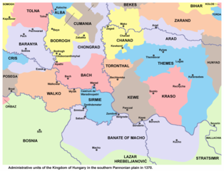
English:
Administrative units of the Kingdom of Hungary in the southern Pannonian plain in 1370.
Српски / srpski:
Административне јединице Краљевине Угарске на југу Панонске низије 1370. године.
|
| Date | |
| Source | Own work |
| Author | PANONIAN |
Licensing
I, the copyright holder of this work, hereby publish it under the following license:
|
|
This file is made available under the Creative Commons CC0 1.0 Universal Public Domain Dedication . |
|
The person who associated a work with this deed has dedicated the work to the
public domain
by waiving all of their rights to the work worldwide under copyright law, including all related and neighboring rights, to the extent allowed by law. You can copy, modify, distribute and perform the work, even for commercial purposes, all without asking permission.
|
References
Borders in the map are made in accordance with this reference:
Secondary references:
- The Times History of Europe, Times Books, London, 2002.
- Istorijski atlas, Geokarta, Beograd, 1999.
- Zbornik "Vojvodina", knjiga I, Fototipsko izdanje, Prometej, Novi Sad, 2008.
- [1] - Géza Pálffy, IZVANREDAN IZVOR O ZEMLJOPISNIM ZNANJIMA UGARSKO-HRVATSKE POLITIČKE ELITE 16. STOLJEĆA.