LDDyfedCantrefi.png

Size of this preview:
800 × 571 pixels
.
Other resolutions:
320 × 228 pixels
|
640 × 457 pixels
|
1,024 × 731 pixels
|
1,344 × 959 pixels
.
Summary
| Description |
English:
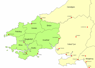
Map of ancient Dyfed, showing its position in southwest Wales, various important medieval towns, and its 7 cantrefs.
|
| Date | 1 October 2007 (original upload date) |
| Source | Transferred from en.wikipedia to Commons. |
| Author | LinguisticDemographer at English Wikipedia |
Licensing
|
|
This work has been released into the
public domain
by its author,
LinguisticDemographer
at
English Wikipedia
. This applies worldwide.
In some countries this may not be legally possible; if so: LinguisticDemographer grants anyone the right to use this work for any purpose , without any conditions, unless such conditions are required by law. |
Original upload log
The original description page was
here
. All following user names refer to en.wikipedia.
- 2007-10-01 20:53 LinguisticDemographer 1344×959×8 (62009 bytes) Map of ancient Dyfed, showing its position in southwest Wales, various important medieval towns, and its 7 cantrefs.