LatinMonetaryUnion_1866-1914.svg

Size of this PNG preview of this SVG file:
450 × 456 pixels
.
Other resolutions:
237 × 240 pixels
|
474 × 480 pixels
|
758 × 768 pixels
|
1,011 × 1,024 pixels
|
2,021 × 2,048 pixels
.
Summary
| Description |
Français :
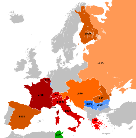
Carte représentant les pays européens participants à l'Union Monétaire Latin entre 1866 et 1914
English:
Map showing the European countries participating at the Latin Monetary Union between 1866 and 1914.
Deutsch:
Übersicht der europäischen Teilnehmer an der Lateinischen Münzunion zwischen 1866 und 1914.
Die Helligkeit kennzeichnet das ungefähre Beitrittsdatum.
|
||||||||||||||||||||||||
| Date | (UTC) | ||||||||||||||||||||||||
| Source |
This file was derived from: |
||||||||||||||||||||||||
| Author |
|
Licensing
This file is licensed under the
Creative Commons
Attribution-Share Alike 3.0 Unported
license.
-
You are free:
- to share – to copy, distribute and transmit the work
- to remix – to adapt the work
-
Under the following conditions:
- attribution – You must give appropriate credit, provide a link to the license, and indicate if changes were made. You may do so in any reasonable manner, but not in any way that suggests the licensor endorses you or your use.
- share alike – If you remix, transform, or build upon the material, you must distribute your contributions under the same or compatible license as the original.
Original upload log
This image is a derivative work of the following images:
-
File:Blank_map_of_Europe_1890.svg
licensed with Cc-by-sa-3.0
- 2012-02-21T02:42:58Z Alphathon 450x456 (444331 Bytes) == {{int:filedesc}} == {{Information |Description={{de|Politische Karte [[:de:Europa|Europas]] ca. 1890}} {{en|A blank map of Europe circa 1890 in SVG format.}} |Source={{Derived from|Europa_1890.jpg|Blank_map_of_Europe.svg|d
-
File:Blank_map_of_Europe_1914.svg
licensed with Cc-by-sa-3.0
- 2012-02-20T23:32:07Z Alphathon 450x456 (462678 Bytes) Fixed Romanian border (Bessarabia should have been Russian)
- 2011-10-31T00:06:48Z Alphathon 450x456 (458338 Bytes) == {{int:filedesc}} == {{Information |Description={{en|Blank map of Europe showing national borders as they stood in 1914.}} |Source=*[[:File:Blank_map_of_Europe.svg|]] |Date=2011-10-31 00:05 (UTC) |Author=*[[:File:Blank_map_
Uploaded with derivativeFX